Zhong Lu
Professor Shuler-Foscue Chair
| Phone |
214-768-0101 |
Education
PH.D., Geophysics, University of Alaska, Fairbanks, Alaska, 9/1992 - 8/1996 M.S., Geophysics, Peking University, Beijing, P. R. China, 9/1989 - 7/1992 B.S., Geophysics, Peking University, Beijing, P. R. China, 9/1985 - 7/1989Research Interests
- Technique developments on 1) synthetic aperture radar (SAR), interferometric SAR (InSAR), persistent scatterer InSAR (PSInSAR) processing, multi-aperture InSAR (MAI) processing and 3D deformation construction from InSAR and MAI/offset measurements, 2) high-resolution digital elevation model (DEM) generation with InSAR, 3) land cover characterization with SAR and Landsat imagery, and 4) InSAR deformation mapping with ERS-1, ERS-2, Radarsat-1, JERS-1, SIR-C, SRTM, Envisat, ALOS-1/-2, TerraSAR-X, TanDEM-X, COSMO-SkyMed, Sentinel-1A/B satellite SAR imagery.
- Research related to volcano deformation mapping, magma supply dynamics from InSAR imagery and numerical modeling, land subsidence and infrastructure stability monitoring and characterization, coastal deformation analysis with InSAR and hydrogeological models, landslide monitoring with InSAR and modeling, mapping and characterization of human-induced (mining, CO2 and wastewater injection, hydrocarbon extraction, sinkhole, ground fissure, etc.) deformation, co-/post-/inter-seismic deformation and seismic slip distribution and fault geometry from InSAR and modeling, imaging water-level changes in wetlands, soil moisture mapping with SAR/InSAR, flood mapping with SAR and optical imagery, vegetation characterization with SAR, glacier dynamics with InSAR, fire scar mapping with SAR and InSAR, arctic ice and water mapping with SAR/InSAR, etc.
Research Highlights
-
1. Subsidence over Gulf Coast
- GEOL 5356: Principle & Application of Remote Sensing
- GEOL 5399: Special Topics in Earth Sciences: Radar Principle & Application
- GEOL 6390: Radar Interferometry
- GEOL 3380: Introduction to Geophysics
- GEOL 6388: Geodynamics
- Basic Geophysics
Land subsidence is known to have occurred in plenty of areas over Gulf of Mexico, and caused extensive damages to manufactured constructions and increase in seawater intrusion leading to substantial loss of wetland habitat and more frequent flooding. The causes of the ground instability in the Gulf Coast are variant. Anthropogenic activities (groundwater withdrawal, oil/gas extraction, wastewater injection), and natural processes (sediment compaction and erosion, adjustment of the solid earth in response to changes in loading, and tectonics) have caused differential ground displacements and even activating faults. The Gulf Coast is vast with a size of ~500,000 km2, and bounded by Texas, Louisiana, Mississippi, Alabama, and Florida. InSAR has the capability to observe the extensive areas using multiple SAR satellites (ERS, ENVISAT, ALOS-1/2, Sentinel-1A/B, TerraSAR-X, COSMO-SkyMed). We have first monitored the ground subsidence over the Houston-Galveston metropolitan and identified the activated faults. Furthermore, we have strived for mapping long-term small and large size deformation over the entire Gulf Coast from InSAR datasets, revealing their causes with supplementary data (GPS, extensometer, wellbore measurements), and understanding geophysical processes.
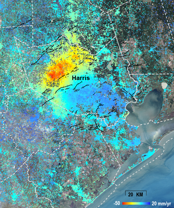 The average ground movement around the Houston area derived from InSAR images obtained from 1995-1998. During that time, the peak land surface drawdown was about 50 mm/year over Harris Country in northwestern Houston [Qu et al., 2015].
Houston-Galveston deformation map (interactive GIS map)
The average ground movement around the Houston area derived from InSAR images obtained from 1995-1998. During that time, the peak land surface drawdown was about 50 mm/year over Harris Country in northwestern Houston [Qu et al., 2015].
Houston-Galveston deformation map (interactive GIS map)

keywords: Gulf of Mexico, Gulf Coast, Land subsidence, Groundwater withdrawal, Wastewater injection, Hydrocarbon extraction, Sinkhole, Salt Dome, InSAR, Deformation mapping.
Grant:
NASA NNX16AL10G, “Mapping and characterizing land deformation over the Gulf Coast using multi-temporal InSAR processing.”
NASA 80NSSC19K1491, “Towards making NISAR a game changer for studying and monitoring volcano, landslide, and human-induced geohazards.”
References:
Qu, F.F., Lu, Z., Zhang, Q., Bawden, G.W., Kim, J.W., Zhao, C.Y., and Qu, W., 2015. Mapping ground deformation over Houston-Galveston, Texas using Multi-temporal InSAR, Remote Sensing of Environment, 169, 290-306. Download PDF
Kim, J.W., and Lu, Z., 2018. Association between localized geohazards in West Texas and human activities, recognized by Sentinel-1A/B satellite radar imagery, Scientific Reports, 8, 4727, https://doi.org/10.1038/s41598-018-23143-6. Download PDF
Zheng, W.Y., Kim, J.W., Ali, S.T., and Lu, Z., 2019. Wastewater leakage in West Texas revealed by satellite radar imagery and numerical modeling, Scientific Reports, 9, 14601, https://doi.org/10.1038/s41598-019-51138-4. Download PDF
Qu, F.F., Lu, Z., Kim, J.W., and Zheng, W.Y., 2019. Identify and monitor growth faulting using InSAR over northern Greater Houston region, Remote Sensing, 11, 1498, doi: 10.3390/rs11121498. Download PDF
2. Landslide studiesLandslide is the downslope movement of soil and/or rock under the influence of gravity, which is an important geomorphologic process, sculpturing the landscapes by transporting large volume of sediment from slopes to catchements through the fluvial system. Particularly, the northwest US undergoes the heavy rainfall in winter, resulting in hundreds of landslides and the expense of federal and state budget for fixing railways, highways, and dams. There has been obvious linkage between two different geohazards (precipitation, landslide), but the analysis of two hazards has been rather fragmented without fully integrating all the associated parameters. We have characterized the major hydrology-driven landslides in the northwest US (Washington, Oregon, northern California) in the large scale with high resolution and accuracy, using radar remote sensing techniques, InSAR, GPM, and SMAP soil moisture. Using multi-frequency SAR satellites (ALOS-1/2, Sentinel-1A/B), we have identified and monitored widespread landslides in northwestern US, which have not been archived to the landslide inventories of the federal and state authorities. Dense vegetation and heavy winter rainfall are major obstacles for landslides studies, but the application of the advanced InSAR techniques has helped unravel previously unidentified landslides from space. In cooperation with USGS, we have successfully completed the state-of-art landslide dynamic modeling for slow-moving and run-out events using D-Claw.
Pacific Northwest InSAR-based Landslide Map (interactive GIS map)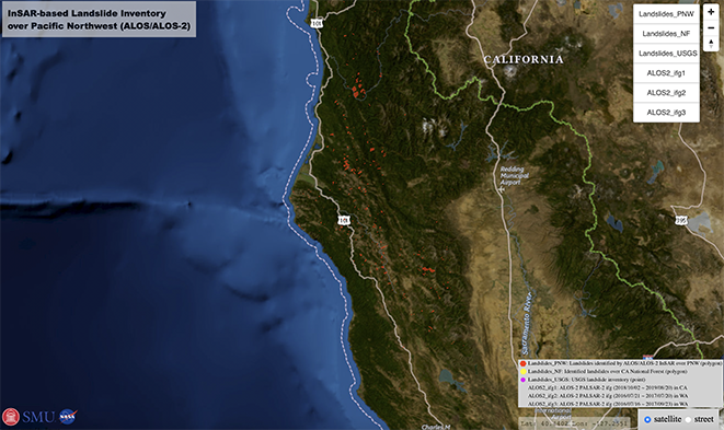
keywords: Landslides, Pacific Northwest, Precipitation, InSAR, Landslide modeling, Landslide runout, D-Claw, Soil moisture, Precipitation, SMAP, GPM.
Grant:
NASA 80NSSC17K0022, “Development of an incorporated platform to characterize hydrology-driven landslide hazards in northwestern US”.
NASA 80NSSC19K1491, “Towards making NISAR a game changer for studying and monitoring volcano, landslide, and human-induced geohazards”.
NASA 80NSSC19K1317, “Using P-band AirMOSS to assess hazards of densely-vegetated deep-seated landslides in the Pacific Northwest”.
USGS Landslide Program, “Landslide studies in Glacier Bay National Park and Preserve and in Puerto Rico”.
References:
Lu, Z., Kim, J.W., 2021. A Framework for Studying Hydrology-Driven Landslide Hazards in Northwestern US Using Satellite InSAR, Precipitation and Soil Moisture Observations: Early Results and Future Directions, GeoHazards, 187, 49-61, https://doi.org/10.3390/geohazards2020002. Download PDF
Xu, Y., Lu, Z., Schulz, W.H., and Kim, J.W., 2020. Twelve-year dynamics and rainfall thresholds for alternating creep and rapid movement of the Hooskanaden landslide from integrating InSAR, pixel offset tracking, and borehole and hydrological measurements, Journal of Geophysical Research: Earth Surface, 125, e2020JF005640, https://doi.org/10.1029/2020JF005640. Download PDF
Hu, X., Lu, Z., Pierson, T., Kramer, R., George, D., 2018. Combining InSAR and GPS to determine transient movement and thickness of a seasonally active low-gradient translational landslide, Geophys. Res. Lett., 45, 1453–1462, doi: 10.1002/2017GL076623. Download PDF
3. InSAR imaging of Aleutian volcanoesWith its global coverage and all-weather imaging capability, InSAR has become an increasingly important technique for studying magma dynamics at volcanoes in remote regions, such as the Aleutian Islands. The spatial distribution of surface deformation derived from InSAR data enables the construction of detailed mechanical models to enhance the study of magmatic processes. To study Aleutian volcanism, Lu and Dzurisin [2014] processed nearly 12,000 SAR images acquired by ERS-1, JERS-1, ERS-2, Radarsat-1, Envisat, ALOS, and TerraSAR-X from the early 1990s to 2010. They combined these SAR images to produce about 25,000 interferograms, which we analyzed for evidence of surface deformation at most of the arc’s Holocene volcanoes. Where surface displacements were sufficiently strong, we used analytical models to estimate the location, shape, and volume change of deformation sources.
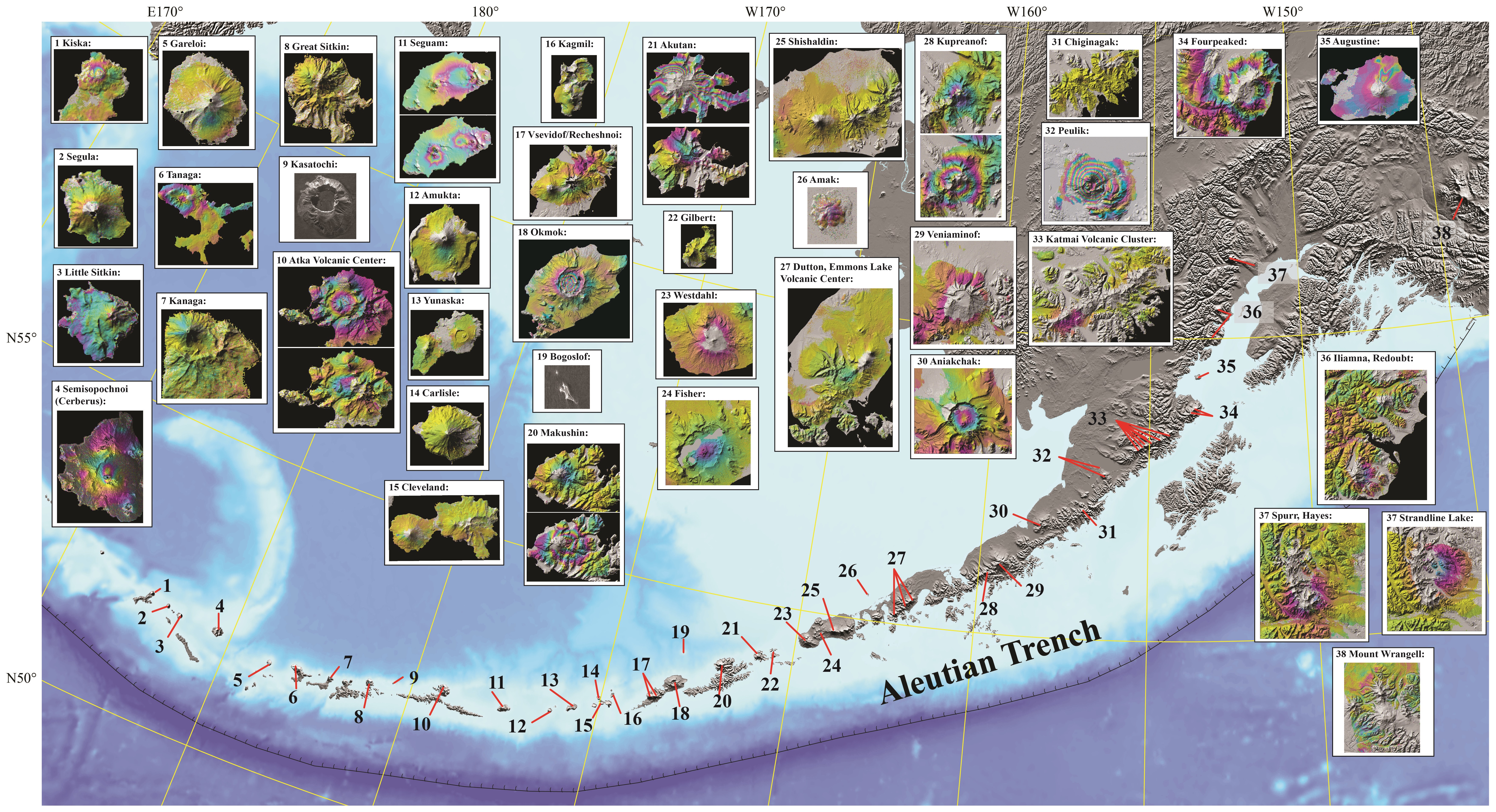 Snapshots of deformation of historically active volcanoes in the Aleutian arc from InSAR [Lu and Dzurisin, 2014].
The deformation processes at Aleutian volcanoes observed with InSAR include: (1) time-variant volcanic inflation and magmatic intrusion, (2) deformation preceding and accompanying seismic swarms, (3) persistent volcano-wide subsidence at calderas that last erupted tens of years ago, (4) episodic magma intrusion and associated tectonic stress release, (5) subsidence caused by a decrease in pore fluid pressure in active hydrothermal systems, (6) subsidence of surface lava and pyroclastic flows, and (7) a lack of deformation at some volcanoes with recent eruptions, where deformation might be expected. Among the inferred mechanisms are magma accumulation in and withdrawal from crustal magma reservoirs, pressurization/depressurization of hydrothermal systems, and thermo-elastic contraction of young lava flows [Lu and Dzurisin, 2014]. Lu and Dzurisin’s work demonstrates that deformation patterns and associated magma supply mechanisms at Aleutian volcanoes are diverse and vary in both space and time. By combining InSAR results with information from the geologic record, accounts of historical eruptions, and data from seismology, petrology, gas geochemistry, and other sources, they have developed conceptual models for the magma plumbing systems and behaviors of many volcanoes in the Aleutian arc. Even though these models are simplistic, but Lu and Dzurisin hope that they will serve as foundations that will be refined as additional information becomes available [Lu and Dzurisin, 2014].
keywords: Aleutian Islands, InSAR, Deformation modeling, Magma dynamics, Inflation, Magmatic intrusion, Seismic swarm, Subsidence, Hydrothermal system, Flow contraction.Grant:
NASA NNX14AD95G, “Real-time monitoring of active volcanoes with an optimized L-band DESDynI-R sensor”.
NASA NNX16AK56G, Toward Making NISAR a Game Changer for Studying Volcanic Processes and Monitoring Volcanic Hazards”.
NASA 80NSSC19K1491, “Towards making NISAR a game changer for studying and monitoring volcano, landslide, and human-induced geohazards.
References;
Lu, Z., and Dzurisin, D., 2014. “InSAR Imaging of Aleutian Volcanoes: Monitoring a Volcanic Arc from Space”: Springer Praxis Books, Geophysical Sciences, ISBN 978-3-642-00347-9, Springer, 390 pp. (http://link.springer.com/book/10.1007%2F978-3-642-00348-6).
EXPERIENCE
11/2013 – present, Shuler-Foscue Professor of Earth Sciences, Southern Methodist University.
12/2006 – 10/2013, Physical Scientist, U.S. Geological Survey, Cascades Volcano Observatory
3/1997 – 11/2006, Principal Scientist &Technical Fellow, Science Applications International Corporation, contractor to the U.S. Geological Survey/EROS,
9/1996 - 2/1997, Postdoctoral Research Associate, Geophysical Institute of University of Alaska
9/1992 - 8/1996, Research Assistant, Geophysical Institute, University of Alaska
COURSES TAUGHT
GRADUATE STUDENT OPPORTUNITIES
I am looking for enthusiastic, persevering students pursuing Ph.D. degrees in geophysics on areas of volcano, landslide, coastal subsidence, and human-induced geohazard using InSAR and deformation modeling.

PUBLICATIONS / MEDIA REPORTS
 |
Lu, Z., and Dzurisin, D., 2014. “InSAR Imaging of Aleutian Volcanoes: Monitoring a Volcanic Arc from Space”: Springer Praxis Books, Geophysical Sciences, ISBN 978-3-642-00347-9, Springer, 390 pp. http://link.springer.com/book/10.1007%2F978-3-642-00348-6 |
|---|---|
 |
NISAR Science Team (including Lu, Z.), 2018. “NASA-ISRO SAR (NISAR) Mission Science Users’ Handbook”, https://nisar.jpl.nasa.gov/files/nisar/ NISAR_Science_Users_Handbook.pdf, pp. 329. |
 |
National Academies of Sciences, Engineering, and Medicine (including Lu, Z.), 2021. “Airborne Platforms to Advance NASA Earth System Science Priorities: Assessing the Future Need for a Large Aircraft”, The National Academies Press, Washington, DC, pp. 172, https://doi.org/10.17226/26079. |
- ABC WFAA News: Wastewater injection well may have leaked undetected for years in West Texas: https://www.wfaa.com/article/news/verify/scientists-find-wastewater-leak-in-west-texas/287-1bc2eb40-9854-4883-bb28-49c1d57052c8
- Youtube: VERIFY: Wastewater injection well may have leaked undetected for years in West Texas: https://www.youtube.com/watch?v=sOGHpz7Id7g
- AAAS EurekAlert!: Wastewater leak in West Texas revealed: https://eurekalert.org/pub_releases/2019-11/smu-wli112519.php
- PHYS.ORG: Wastewater leak in West Texas revealed by satellite radar imagery and sophisticated modeling: https://phys.org/news/2019-11-wastewater-leak-west-texas-revealed.html
- Water Online: Wastewater Leak In West Texas Revealed By Satellite Radar Imagery And Sophisticated Modeling: https://www.wateronline.com/doc/wastewater-leak-in-west-texas-revealed-radar-imagery-and-sophisticated-modeling-0001
- Environmental News Network: Wastewater Leak in West Texas Revealed by Satellite Radar Imagery and Sophisticated Modeling: https://www.enn.com/articles/60971-wastewater-leak-in-west-texas-revealed-by-satellite-radar-imagery-and-sophisticated-modeling
- The Big Bend Sentinel: Researchers find leak in West Texas injection well: https://bigbendsentinel.com/2019/12/18/researchers-find-leak-in-west-texas-injection-well/
- News: Wide Sections Of Texas Are Sinking And Growing - A team from SMU made the discovery using satellite radar: http://dfw.cbslocal.com/video/category/news/3834721-wide-sections-of-texas-are-sinking-and-growing/
- WFAA ABC TV: Verify: Is West Texas sinking?: http://www.wfaa.com/article/news/local/verify-is-west-texas-sinking/287-542935783
- CW33 TV News: SMU reports sinkholes developing at alarming rates: http://cw33.com/2018/03/24/smu-reports-sinkholes-developing-at-alarming-rates/
- KABB Fox TV 29: Study shows a large part of West Texas is sinking at an alarming rate: http://foxsanantonio.com/news/local/a-study-shows-a-large-part-of-west-texas-is-sinking-at-an-alarming-rate
- CW39 TV: http://cw39.com/2018/03/29/famous-giant-sinkholes-in-winkler-county-getting-bigger-according-to-smu-study/
- Texas Standard: http://www.texasstandard.org/stories/dont-park-your-car-in-parts-of-the-permian-basin-researchers-say-theyre-sinking/
- Industrial Equipment News: https://www.ien.com/video/video/20997850/source-of-massive-sinkholes-confirmed
- SMU press release: http://blog.smu.edu/research/2018/03/20/radar-images-show-large-swath-of-texas-oil-patch-is-heaving-and-sinking-at-alarming-rates/
- WFAA Verify – Is West Texas sinking:http://blog.smu.edu/research/2018/04/19/wfaa-verify-is-west-texas-sinking/
- ABC KTXS 12: http://ktxs.com/news/texas/a-study-shows-a-large-part-of-west-texas-is-sinking-at-an-alarming-rate
- Texas Monthly: https://www.texasmonthly.com/politics/sinkholes-west-texas/
- Marfa Public Radio: http://marfapublicradio.org/blog/research-says-areas-of-west-texas-sinking-at-high-rates/
- The Guardian: https://www.theguardian.com/world/2018/mar/27/texas-sinkholes-oil-gas-scientists-report
- KFYO News: http://kfyo.com/huge-parts-of-texas-are-sinking-at-an-alarming-rate/
- MSN
- Jacksonville Progress: http://www.jacksonvilleprogress.com/news/state-studies-relocating-miles-of-west-texas-road-as-sinkholes/article_48e3d00a-335e-11e8-8fad-f781193bb3a1.html
- Common Dreams: https://www.commondreams.org/news/2018/03/27/punctured-pin-cushion-oil-and-gas-drilling-scientists-warn-growing-sinkhole-threat
- The Eagle: http://www.theeagle.com/news/texas/large-portions-of-west-texas-sinking-at-alarming-rate-new/article_394a4151-e03e-50f4-98b8-68596683fb24.html
- Inverse Science: https://www.inverse.com/article/42712-west-texas-sinkholes-oil-drilling-fluid-injection
- Political and Science Rhymes: http://politicalandsciencerhymes.blogspot.com/2018/03/massive-oil-fields-in-texas-sinking-at.html
- Outer Places: https://www.outerplaces.com/science/item/18188-geophysicists-oil-extraction-texas-land-sink-warp
- From The Trenches: http://fromthetrenchesworldreport.com/massive-oil-fields-in-texas-are-heaving-sinking-and-opening-up-like-mouths/221938
- TexasVox - The Voice of Public Citizen in Texas: http://www.texasvox.org/large-swath-texas-oil-patch-heaving-sinking-alarming-rates-wcs-wants-store-high-level-radioactive-waste-nearby/
- Oklahoma Energy Today: http://www.okenergytoday.com/2018/03/sinkholes-growing-in-west-texas/
- Learning Freely: https://www.alternative-learning.org/nl/wordpress/?p=40213
- IGO News: http://igo.news/famous-giant-sinkholes-in-winkler-county-getting-bigger-according-to-smu-study/
- OHS Online: https://ohsonline.com/articles/2018/03/26/ground-movement-linked-to-oil-drilling.aspx
- Wireless Design Magazine: https://www.wirelessdesignmag.com/blog/2018/03/week-photos-first-time-industry-wearables-jupiters-red-storm-sinkholes-texas
- Earthsky: http://earthsky.org/earth/4-west-texas-counties-heaving-and-sinking
- Forbes: https://www.forbes.com/sites/trevornace/2018/03/28/massive-oil-fields-in-texas-are-heaving-and-sinking-at-alarming-rates/#3fcf9fcac8b3
- EurekaAlert: https://www.eurekalert.org/pub_releases/2018-03/smu-ris032118.php
- Phys.org: https://phys.org/news/2018-03-radar-images-large-swath-texas.html
- Dallas Morning News: https://www.dallasnews.com/business/energy/2018/03/22/sinkholes-permian-basin-bucking-stress-oil-gas-drilling-study-says
- San Francisco Chronicle: https://www.sfchronicle.com/news/local/article/Study-finds-grounds-are-moving-and-sinking-in-12778834.php
- Houston Chronicle: https://www.chron.com/news/houston-texas/texas/article/West-Texas-should-get-prepared-for-more-12776100.php
- San Antonio Express: https://www.mysanantonio.com/news/local/article/Study-finds-grounds-are-moving-and-sinking-in-12773508.php
- Texas Tribune: https://www.texastribune.org/2018/03/22/report-says-large-portions-west-texas-counties-are-sinking-alarming-ra/
- HPPR: http://hppr.org/post/radar-shows-huge-patch-west-texas-land-shifting
- ScienceDaily: https://www.sciencedaily.com/releases/2018/03/180321110855.htm
- Independent: https://www.independent.co.uk/environment/fracking-oil-gas-drilling-blamed-sinkholes-threatening-swallow-texas-earthquakes-a8281281.html
- NewsBlogged.com: http://newsblogged.com/radar-images-show-large-swath-of-texas-oil-patch-is-heaving-and-sinking-at-alarming-rates/
- BrightSurf.com: https://www.brightsurf.com/news/article/032118452483/radar-images-show-large-swath-of-texas-oil-patch-is-heaving-and-sinking-at-alarming-rates.html
- Laboratory Equipment: https://www.laboratoryequipment.com/news/2018/03/texas-oil-patch-heaving-sinking-alarming-rate
- Insight News: https://businessmanagement.news/2018/03/29/oil-and-gas-drilling-causing-sinkholes-across-texas/
- San Francisco Gate: https://www.sfgate.com/news/local/article/Study-finds-grounds-are-moving-and-sinking-in-12778834.php
- Wireless: https://www.wirelessdesignmag.com/news/2018/03/radar-images-show-large-swath-texas-oil-patch-heaving-and-sinking-alarming-rates
- Fluid Handling International: https://fluidhandlingmag.com/display_news/13545/research_links_shifting_ground_in_texas_to_fluid_injection_at_oil_wells/
- Science Newsline: http://www.sciencenewsline.com/news/2018032201480057.html
- International Business Times: http://www.sciencenewsline.com/news/2018032201480057.html
- Science Alert: https://www.sciencealert.com/massive-oil-fields-in-texas-are-heaving-sinking-and-opening-up-like-mouths-wink-sinkholes-geohazard
- Chem.Info: https://www.chem.info/news/2018/03/texas-oil-patch-heaving-and-sinking-alarming-rates
- Houston Public Media: https://www.houstonpublicmedia.org/articles/news/2018/03/22/274799/large-portions-of-west-texas-sinking-at-alarming-rate-new-report-finds/
- HomelandSecurity News Wire: http://www.homelandsecuritynewswire.com/dr20180323-large-swath-of-west-texas-oil-patch-is-heaving-and-sinking-at-alarming-rates
- Geology Page: http://www.geologypage.com/2018/03/radar-images-show-large-swath-of-texas-oil-patch-is-heaving-and-sinking-at-alarming-rates.html
- Tyler Paper: https://tylerpaper.com/news/texas/large-portions-of-west-texas-sinking-at-alarming-rate-new/article_10390252-2edb-11e8-abe2-83699a0a3dc6.html
- Big Country Homepage:http://www.bigcountryhomepage.com/news/main-news/smu-study-shows-parts-of-west-texas-susceptible-to-sink-holes/1070681494
- Weatherford: http://www.weatherforddemocrat.com/news/local_news/studies-relocating-miles-of-road-as-sinkholes-spread/article_1b0bbe97-cd3d-553b-9046-94543ad6ba59.html
- Fort Worth Business: http://www.weatherforddemocrat.com/news/local_news/studies-relocating-miles-of-road-as-sinkholes-spread/article_1b0bbe97-cd3d-553b-9046-94543ad6ba59.html
- Eagle Pass Business Journal: http://www.epbusinessjournal.com/2018/03/large-portions-of-west-texas-sinking-at-alarming-rate-new-report-finds/
- Magnerd: http://magnerd.com/more-sinkholes-could-form-as-texas-is-punctured-like-a-pin-cushion/
- InfoGlitz
- Tch2
- Notey: http://www.notey.com/@inhabitat_unofficial/external/20313886/the-ground-under-a-west-texas-oil-patch-is-moving-at-alarming-rates.html
- The Energy Mix: http://theenergymix.com/2018/03/25/punctured-like-a-pin-cushion-texas-oilpatch-is-sinking-geophysically-speaking/
- Periodismo Alternativo:
- Actualidad RT: https://actualidad.rt.com/actualidad/266617-revelar-consecuencias-extraccion-petroleo-eeuu
- Buzzflash: http://buzzflash.com/commentary/large-swath-of-texas-oil-patch-rapidly-sinking-and-uplifting-study-finds
- All of It
- Source Update: https://sourceupdates.com/extra-sinkholes-might-kind-as-texas-is-punctured-like-a-pin-cushion/
- Snooze Press: https://snooze.press/2018/03/oil-and-gas-drilling-blamed-for-giant-sinkholes-threatening-to-swallow-parts-of-texas/
- Tech2
- The Watchers: https://watchers.news/2018/03/23/west-texas-oil-patch-heaving-and-sinking-at-alarming-rates/?utm_source=feedburner&utm_medium=feed&utm_campaign=Feed%3A+adorraeli%2FtsEq+%28The+Watchers+-+watching+the+world+evolve+and+transform%29
- EcoWatch: https://www.ecowatch.com/west-texas-sinkhole-2551781426.html
- North Texas e-news: http://www.ntxe-news.com/artman/publish/article_110398.shtml
- Viral Stories
- True Viral News
- Oilprice.com: https://oilprice.com/Latest-Energy-News/World-News/Study-Says-West-Texas-Ground-Sinks-Under-Permian-Oil-Drilling.html
- Kallanish Energy News: https://www.kallanishenergy.com/2018/03/23/large-swath-of-west-texas-permian-basin-heaving-sinking/
- Tech Times: http://www.techtimes.com/articles/223644/20180325/radar-images-reveal-major-ground-movement-and-sinking-in-texas-oil-patch.htm
- Digital Journal: http://www.digitaljournal.com/tech-and-science/technology/ground-under-a-west-texas-oil-patch-is-moving-at-an-alarming-rate/article/518291
- Inhabitat: https://inhabitat.com/the-ground-under-a-west-texas-oil-patch-is-moving-at-alarming-rates/
- Europa Press: http://www.europapress.es/ciencia/habitat-y-clima/noticia-alarmantes-movimientos-tierra-cuenca-petrolifera-texas-20180321171346.html
- Designs by Lindaturner: https://designsbylindaturner.com/sinkholes-linked-to-oil-industry-are-threatening-to-swallow-part-of-texas/
- I4U News: https://www.i4u.com/2018/03/127601/more-massive-sinkholes-could-form-texas-says-study
- Scienxx: http://www.scinexx.de/wissen-aktuell-22558-2018-03-22.html
- Sign of the Times: https://www.sott.net/article/381012-The-heaving-and-sinking-oil-wells-of-Wink-Texas
- RT Network: https://actualidad.rt.com/actualidad/266617-revelar-consecuencias-extraccion-petroleo-eeuu?utm_source=rss&utm_medium=rss&utm_campaign=all
- Occupational Health & Safety: https://ohsonline.com/articles/2018/03/26/ground-movement-linked-to-oil-drilling.aspx?admgarea=ht.RiskManagement
- LiveScience: https://www.livescience.com/62117-west-texas-sinking-into-hole.html
- EP Magazine: https://eponline.com/articles/2018/03/26/ground-movement-linked-to-oil-drilling.aspx
- SeattlePI: https://www.seattlepi.com/news/local/article/Study-finds-grounds-are-moving-and-sinking-in-12778834.php
- Health Thorough Fare: https://www.healththoroughfare.com/science/an-environmental-catastrophe-can-happen-in-texas-any-time-due-to-massive-oil-extraction-operations/6530
- International Business Times: http://www.ibtimes.com/texas-oil-drilling-causes-alarming-increase-land-sinking-satellite-images-show-2665090
- Natural Gas Intelligence: http://www.naturalgasintel.com/articles/113821-permians-shifting-sinking-ground-not-normal-say-smu-researchers
- IFLscience: http://www.iflscience.com/environment/sinkholes-linked-oil-industry-threatening-swallow-part-texas/
- MRT: https://www.mrt.com/news/local/article/West-Texas-sinkhole-studies-show-more-reasons-for-12815531.php
- Cleburne-Times Review: http://www.cleburnetimesreview.com/texas/state-studies-relocating-miles-of-west-texas-road-as-sinkholes/article_cfe7f634-3206-11e8-a22f-bf53dd5df8a7.html
- Giustizi Ambientale
- Pollution Solutions: https://www.pollutionsolutions-online.com/news/analytical-instrumentation/11/breaking-news/what39s-causing-sinkholes-to-emerge-in-texas/45788
- 106.3 The BUZZ Radio: http://1063thebuzz.com/huge-parts-of-texas-are-sinking-at-an-alarming-rate/
- NPR KUT New: http://kut.org/post/don-t-park-your-car-parts-permian-basin-researchers-say-they-re-sinking
- NPR KERA News: http://keranews.org/post/large-portions-west-texas-sinking-alarming-rate-new-report-finds
- NPR KERA News: http://keranews.org/post/don-t-park-your-car-parts-permian-basin-researchers-say-they-re-sinking
- SMU Blog
- "Geohazard: Giant sinkholes near West Texas oil patch towns are growing — as new ones lurk” was reported in many news media
- Science Daily: https://www.sciencedaily.com/releases/2016/06/160614121526.htm
- New York Daily News: http://www.nydailynews.com/news/national/giant-sinkholes-texas-growing-collide-study-article-1.2676778
- San Antonio News: http://www.mysanantonio.com/news/local/article/Two-huge-sinkholes-threaten-tiny-Texas-town-8313203.php
- Texas Tribune: https://www.texastribune.org/2016/07/12/west-texas-county-unfazed-headlines-portending-sin/
- Texas Standard: http://www.texasstandard.org/stories/winks-sinkholes-are-growing-and-its-the-pits/
- KERA News: http://keranews.org/post/near-wink-texas-sink-holes-are-getting-bigger-and-bigger
- Houston Chronicle: http://www.chron.com/news/local/article/Two-huge-sinkholes-threaten-tiny-Texas-town-8313203.php
- CBS 7: http://www.cbs7.com/content/news/Two-Giant-Sinkholes-in-West-Texas-Expanding-Researchers-Say-383414881.html
- Boston NPR (90.9 WBUR-FM): http://www.wbur.org/hereandnow/2016/06/28/wink-texas-sink-holes
- WOSU Radio: http://radio.wosu.org/post/near-wink-texas-sink-holes-are-getting-bigger-and-bigger
- EurekaAlert: http://www.eurekalert.org/pub_releases/2016-06/smu-ggs061416.php
- Scienmag: http://scienmag.com/geohazard-giant-sinkholes-near-west-texas-oil-patch-towns-are-growing-as-new-ones-lurk/
- Phys.org: http://phys.org/news/2016-06-geohazard-giant-sinkholes-west-texas.html
- GRIST: http://grist.org/living/massive-sinkholes-in-texas-could-combine-to-form-even-massiver-sinkhole
- Business Insider: http://www.businessinsider.com/massive-sinkholes-texas-could-form-even-massiver-sinkhole-2016-6
- International Business Times: http://www.ibtimes.co.uk/texas-giant-unstable-sinkholes-are-growing-could-be-verge-catastrophic-collapse-1565636
- The Watcher: http://thewatchers.adorraeli.com/2016/06/14/giant-sinkholes-in-wink-region-expanding-pose-serious-hazard-texas/
- Daily Mail: http://www.dailymail.co.uk/news/article-3645090/Two-Texas-sinkholes-growing-unstable-verge-creating-one-giant-hole.html
- Star-Telegram: http://www.star-telegram.com/news/state/texas/article84269782.html
- The Weather Network: http://www.theweathernetwork.com/news/articles/two-giant-sinkholes-at-risk-of-colliding-in-texas/69111/
- Strange Sounds: http://strangesounds.org/2016/06/two-infamous-sinkholes-expand-wink-kermit-texas-growing-wink-sinkholes-photo-video.html
- Energy Today: http://okenergytoday.com/2016/06/19010
- Mysterious Universe: http://mysteriousuniverse.org/2016/06/parts-of-texas-disappearing-into-sinkholes
- Investment Watch
- US 105: http://us105fm.com/two-texas-sinkholes-on-the-verge-of-one-giant-collapse
- Science Newsline
- Worldpress: https://jasperandsardine.wordpress.com/2016/06/16/twin-texas-sinkholes-growing-and-unstable/
- Twitter: https://twitter.com/search?q=%23sinkholes
- Facts Legend: http://factslegend.org/texas-sinkholes-texas-disappearing-netherworld/
- Science World Report: http://www.scienceworldreport.com/articles/42436/20160618/geophysicists-discover-growing-unstable-texas-sinkholes.htm
- Sott Net: https://www.sott.net/article/320452-Two-giant-sinkholes-at-risk-of-colliding-in-Texas-claim-researchers
- Chron: http://www.chron.com/news/local/article/Two-huge-sinkholes-threaten-tiny-Texas-town-8313203.php
- Tomo News: http://us.tomonews.com/sinkholes-in-texas-expanding-at-an-alarming-rate-catastrophic-collapse-may-occur-3081851
- Dark Thirty News
- Glock Talk
- Dbtechno.com: http://www.dbtechno.com/curiosity/2016/06/17/107937/
- Allianz Travel Insurance: http://allianz-travelinsurance.com/news/Giant-sinkholes-in-Texas-are-growing,-may-collide:-study/
- I4U News: http://www.i4u.com/2016/06/112542/two-giant-sinkholes-texas-are-expanding-may-collapse-each-other-study-warns
- Ooyuz: http://www.ooyuz.com/geturl?aid=12036847
- Examiner.com: http://www.examiner.com/article/texas-sinkholes-a-mile-apart-show-alarming-growth-collapsing-into-one-sinkhole
- Lab Manager Magazine: http://www.labmanager.com/news/2016/06/giant-sinkholes-near-west-texas-oil-patch-towns-are-growing-as-new-ones-lurk#.V22j2FdLVJo
- Seeker.com: http://www.seeker.com/giant-sinkholes-near-texas-oil-fields-are-growing-1863056864.html
- Construction Equipment Guide: http://www.constructionequipmentguide.com/two-texas-sinkholes-are-getting-bigger-more-dangerous/29536
- Tech Times: http://www.techtimes.com/articles/165865/20160619/two-massive-texas-sinkholes-may-collapse-into-each-other-and-form-new-gigantic-hole.htm
- Newswise: http://www.newswise.com/articles/view/655360/?sc=rsla
- RT Network: https://actualidad.rt.com/actualidad/210598-gigantes-agujeros-fusionarse-catastrofe-eeuu
- Eurasia Review: http://www.eurasiareview.com/15062016-giant-sinkholes-near-west-texas-oil-patch-towns-growing-as-new-ones-lurk/
- Apple Daily.com: http://www.appledaily.com.tw/realtimenews/article/new/20160622/891853/
- Redaksi
- News 1: http://news1.kr/articles/?2694736
- Now news: http://nownews.seoul.co.kr/news/newsView.php?id=20160617601022
- China Phoenix News: http://i.ifeng.com/news/sharenews.f?aid=110308487&from=groupmessage&isappinstalled=
- AGU Blog: Using InSAR to create a landslide inventory for the Pacific Northwest: https://blogs.agu.org/landslideblog/2021/10/01/using-insar-to-create-a-landslide-inventory-for-the-pacific-northwest/
- Florida News Times: Scientists detect new landslides on the west coast of the United States
- My Droll: Scientists detect new landslides on U.S. West Coast: https://mydroll.com/scientists-detect-new-landslides-on-u-s-west-coast/
- EurekAleart: New landslides on US West Coast detected by SMU scientists:https://www.eurekalert.org/news-releases/929740
- Phys.org: Scientists detect new landslides on U.S. West Coast: https://phys.org/news/2021-09-scientists-landslides-west-coast.html
- Our Planet: The Landslide(s) Bring It Down: https://www.ourdailyplanet.com/story/the-landslides-bring-it-down/
- Gamers Grade: Scientists detect new landslides on U.S. West Coast: https://gamersgrade.com/scientists-detect-new-landslides-on-u-s-west-coast/
- Urallnews: Scientists detect new landslides on U.S. West Coast: https://bigworldfree4u.com/us-news/scientists-detect-new-landslides-on-the-west-coast-of-the-united-states/
- Conservation West Virginia: The Landslide(s) Bring It Down: https://www.conservewv.org/the-landslides-bring-it-down/
- Fast News: Scientists detect new landslides on U.S. West Coast: https://thefastnewz.com/scientists-detect-new-landslides-on-u-s-west-coast/
258. Jiang, Y., Liao, L., Luo, H., Zhu, X., and Lu, Z., 2023. Multi-scale response analysis and displacement prediction of landslide using deep learning with JTFA: a case study in the Three Gorges Reservoir, China: Remote Sensing, 15, 3995, https://doi.org/10.3390/rs15163995.
257. Wang, S., Lu, Z., Wang, B., Niu, Y., Song, C., Li, X., Ma, Z., Xu, C., 2023. A Phase-based InSAR Tropospheric Correction Method for Interseismic Deformation Based on Short-period Interferograms: IEEE Transactions on Geoscience and Remote Sensing, 61, doi:10.1109/TGRS.2023.3296958.
256. Karanam, V., Lu, Z., 2023, Hydrocarbon Production Induced Land Deformation Over Permian Basin; Analysis Using Persistent Scatterer Interferometry And Numerical Modeling, International Journal of Applied Earth Observation and Geoinformation, 122, 103424, https://doi.org/10.1016/j.jag.2023.103424.
255. Han, Y., Li, T., Dai, K., Lu, Z., Yuan, X., Shi, X., Liu, C., Wen, N., Zhang, X., 2023. Revealing the Land Subsidence Deceleration in Beijing (China) by Gaofen-3 Time Series Interferometry. Remote Sens., 15, 3665. https://doi.org/10.3390/rs15143665.
254. Zheng, W., Hu, J., Lu, Z., Hu, X., Sun, Q., Liu, J., et al., 2023. Enhanced kinematic inversion of 3-D displacements, geometry, and hydraulic properties of a north-south slow-moving landslide in Three Gorges Reservoir: Journal of Geophysical Research: Solid Earth, 128, e2022JB026232. https://doi.org/10.1029/2022JB026232.
253. Kang, Y., Lu, Z.*, Zhao, C., and Qu, W., 2023. Inferring Slip-surface Geometry and Volume of Creeping Landslides Based on InSAR: A Case Study in Jinsha River Basin: Remote Sensing of Environment, 294, 113620, https://doi.org/10.1016/j.rse.2023.113620.
252. Zheng, W., Lu, Z., Kim, J.W., 2023. Bayesian Monte Carlo inversion of InSAR time series deformation induced by wastewater injection: A case study in West Texas: Geophysical Research Letters, 50, e2023GL102991. https://doi.org/10.1029/2023GL102991.
251. Wang, B., Zhao, C., Zhang, Q., Liu, X., Lu, Z., Liu, C., Zhang, J., 2023. Sequential DS-ISBAS InSAR Deformation Parameter Dynamic Estimation and Quality Evaluation, Remote Sensing, 15(8), 2097; https://doi.org/10.3390/rs15082097.
250. Xu, Y., Lu, Z., Burgmann R., Hensley, S., Fielding, E., Kim, J.W., 2023.P-band SAR for ground deformation surveying: Advantages and challenges: Remote Sensing of Environment, 287, 113474, https://doi.org/10.1016/j.rse.2023.113474.
249. Liang, H., Zhang, L., Lu, Z., and Li, X., 2023. Correction of spatially varying stratified atmospheric delays in multitemporal InSAR: Remote Sensing of Environment, 285, 113382, https://doi.org/10.1016/j.rse.2022.113382.
248. Qu, F.,Lu, Z.*, Kim, J.W., Turco, M.J., 2023. Mapping and characterizing land deformation during 2007-2011 over the Gulf Coast by L-band InSAR: Remote Sensing of Environment, 284, 113342, https://doi.org/10.1016/j.rse.2022.113342.
247. Liu, Y., Yan, X., Xia, Y., Liu, B.,Lu, Z., Yu, M. 2022. Characterizing Spatiotemporal Patterns of Land Subsidence after the South‑to‑North Water Diversion Project Based on Sentinel‑1 InSAR Observations in the Eastern Beijing Plain: Remote Sens., 14, 5810, https://doi.org/10.3390/rs14225810.
246. Chen, X., Zhao, C., Xi, J., Lu, Z., Ji, S., Chen, L., 2022. Deep Learning Method of Landslide Inventory Map with Imbalanced Samples in Optical Remote Sensing: Remote Sensing, 14, 5517, https://doi.org/10.3390/rs14215517.
245. Kim, J.W., Coe, J.A., Lu, Z.*, Avdievitch, N.N., Hults, C.P., 2022. Spaceborne InSAR mapping of landslides and subsidence in rapidly deglaciating terrain, Glacier Bay National Park and Preserve and vicinity, Alaska and British Columbia, Remote Sensing of Environment, 281, 113231, https://doi.org/10.1016/j.rse.2022.113231.
244. Zhang, L., Lu, Z.*, 2022. Advances in InSAR Imaging and Data Processing—A Review: Remote Sens., 14, 4307, https://doi.org/10.3390/rs14174307.
243. Wu, S., Ding, X., Zhang, B., Ding, X., Shahzad, N., Zhang, L., and Lu, Z., 2022. A hybrid method for MT-InSAR phase unwrapping for deformation monitoring in urban areas: International Journal of Applied Earth Observation and Geoinformation, 112, 102963, https://doi.org/10.1016/j.jag.2022.102963.
242. Lou, B., Zhu, H., Yang, J., Lay, T., Ye, L., Lu, Z., Lumley, D., 2022. Detecting and locating aftershocks for the 2020 MW 6.5 Stanley, Idaho earthquake using convolutional neural networks, Seismological Research Letters, https://doi.org/10.1785/0220210341.
241. Zhang, Y., Wei, J., Duan, D., Kang, Y., He, Q., Wu, H., Lu, Z., 2022. Coherent Pixel Selection Using a Dual-Channel 1-D CNN for Time Series InSAR Analysis: International Journal of Applied Earth Observations and Geoinformation, 112, 102927, https://doi.org/10.1016/j.jag.2022.102927.
240. Yin, Y.P., Liu, X.J., , Zhao, C.Y., Roberto, T., Zhang, Q., Lu, Z., Li, B., 2022. Multi-dimensional and long-term time series monitoring and early warning of landslide hazard with improved cross-platform SAR offset tracking method: Sci China Tech Sci, 65, https://doi.org/10.1007/s11431-021-2008-6.
239. Dai, C., Howat, I.M., Freymueller, J.T., Lu, Z., Vijay, S., Liljedahl, A.K., Jones, W., Bergstedt, H., Lev, E.., 2022. Quantifying mass flows at Mt. Cleveland, Alaska between 2001 and 2020 using satellite photogrammetry: Journal of Volcanology and Geothermal Research, 429, 107614, https://doi.org/10.1016/j.jvolgeores.2022.107614.
238. Qu, F., Zhang, Q., Niu, Y., Lu, Z., Wang, S., Zhao, C., Zhu, W., Qu, W., and Yang, C., 2022. Mapping the Recent Vertical Crustal Deformation of the Weihe Basin (China) Using Sentinel-1 and ALOS-2 ScanSAR Imagery: Remote Sens., 14, 3182, https://doi.org/10.3390/rs14133182.
237. Jiang, Y., Luo, H., Xu, Q., Lu, Z., Liao, L., Li, H., and Hao, L. 2022. A Graph Convolutional Incorporating GRU Network for Landslide Displacement Forecasting Based on Spatiotemporal Analysis of GNSS Observations: Remote Sens., 14, 1016, https://doi.org/10.3390/rs14041016.
236. Xu, Y., Lu, Z., & Leshchinsky, B., 2022. Kinematics of irrigation-induced landslides in a Washington desert: Impacts of basal geometry: Journal of Geophysical Research: Earth Surface, 127, e2021JF006355, https://doi.org/10.1029/2021JF006355.
235. Yang, L., Lu, Z.*, Zhao, C., Kim, J.W., Yang, C., Wang, B., Liu, X., and Wang, Z., 2022. Analyzing the triggering factors of glacial lake outburst floods with SAR and optical images: a case study in Jinweng Co, Tibet, China: Landslides, 19, doi:10.1007/s10346-021-01831-1.
234. Peng, M., Lu, Z.*, Zhao, C., Motagh, M., Bai, L., Conway, B.D., Chen, H., 2022. Mapping land subsidence and aquifer system properties of the Willcox Basin, Arizona, from InSAR observations and independent component analysis: Remote Sensing of Environment, 271, https://doi.org/10.1016/j.rse.2022.112894.
233. Xu, Y., Lu, Z., Kim, J.W., 2021. P-Band InSAR for Geohazard Detection over Forested Terrains: Preliminary Results: Remote Sens., 13, 4575, https://doi.org/10.3390/rs13224575.
232. Liu, X., Zhao, C., Zhang, Q., Yin, Y., Lu, Z., Samsonov, S., Yang, C., Wang, M., Tomás, R., 2021.Three-dimensional and long-term landslide displacement estimation by fusing C- and L-band SAR observations: A case study in Gongjue County, Tibet, China: Remote Sensing of Environment, 267, 112745, https://doi.org/10.1016/j.rse.2021.112745.
231. Wang, J., Lu, Z.*, and Gregg, P.M., 2021. Inflation of Okmok volcano during 2008–2020 from PS analyses and source inversion with finite element models: Journal of eophysical Research: Solid Earth, 126, e2021JB022420, https://doi.org/10.1029/2021JB022420
230. Kim, J.W., and Lu, Z.*, 2021. Sinkholes in Wink, Texas, Observed by Satellite Radar Imagery, in Johnson, K. S.; Land, Lewis; and Decker, D. D. (eds.), Evaporite Karst in the Greater Permian Evaporite Basin (GPEB) of Texas, New Mexico, Oklahoma, Kansas, and Colorado: Oklahoma Geological Survey Circular 113, 105–110.
229. Xu, Y., Schulz, H. W., Lu, Z., Kim, J. W., and Baxstrom, K., 2021. Geologic controls of slow-moving landslides near the U.S. West Coast: Landslides, 18, doi:10.1007/s10346-021-01732-3.
228. Wang, B.H., Zhao, C.Y., Zhang, Q., Lu, Z., and Pepe, A., 2021. Long-Term Continuously Updated Deformation Time Series from Multi-Sensor InSAR in Xi’an, China from 2007 to 2021, IEEE Journal of Selected Topics in Applied Earth Observations and Remote Sensing, 14, 7297-7309, doi:10.1109/JSTARS.2021.3096996
227. Reath, K., Pritchard, M.E., Roman, D.C., Lopez, T., Carn, S., Fischer, T.P., Lu, Z., Poland, M.P., Vaughan, R., Wessels, R., Wike, L.L., Tran, L.K., 2021. Quantifying Eruptive and Background Seismicity, Deformation, Degassing, and Thermal Emissions at Volcanoes in the United States During 1978-2020, Journal of Geophysical Research, 126, e2021JB021684, doi:10.1029/2021JB021684.
226. Wang, B.H., Zhang, Q., Pepe, A., Mastro, P., Zhao, C.Y., Lu, Z., Zhu, W., Yang, C.S., Zhang, J., 2021. Analysis of Groundwater Depletion/Inflation and Freeze–Thaw Cycles in the Northern Urumqi Region with the SBAS Technique and an Adjusted Network of Interferograms, Remote Sensing, 13, 2144. https://doi.org/10.3390/rs13112144.
225. National Academies of Sciences, Engineering, and Medicine (including Lu, Z.), 2021. Airborne Platforms to Advance NASA Earth System Science Priorities: Assessing the Future Need for a Large Aircraft. The National Academies Press, Washington, DC, pp. 172, https://doi.org/10.17226/26079.
224. Yang, Y.D., Zhu, H.J., Lay, T., Niu, Y.F., Ye, L.L., Lu, Z., Luo, B.X., Kanamori, H., Huang, J.P., Li, Z.C., 2021. Multi-fault opposing-dip strike-slip and normal-fault rupture during the 2020 Mw 6.5 Stanley, Idaho earthquake, Geophys. Res. Lett., 48, e2021GL092510, doi:10.1029/2021GL092510.
223. Lu, Z.*, Kim, J.W., 2021. A Framework for Studying Hydrology-Driven Landslide Hazards in Northwestern US Using Satellite InSAR, Precipitation and Soil Moisture Observations: Early Results and Future Directions. GeoHazards, 2, 17–40, https://doi.org/10.3390/geohazards2020002.
222. Kang, Y., Lu, Z.*, Zhao, C.Y., Xu, Y.K., Kim, J.W., and Gallegos, A.J., 2021. InSAR Monitoring of Creeping Landslides in Mountainous Regions: A Case Study in Eldorado National Forest, California, Remote Sensing of Environment, 258, 112400.
221. Liu, X.J., Zhao, C.Y., Zhang, Q., Lu, Z., and others, 2021. Integration of Sentinel-1 and ALOS/PALSAR-2 SAR datasets for mapping active landslides along the Jinsha River corridor, China, Eng. Geology, 284, doi:10.1016/j.enggeo.2021.106033.
220. Jiang, Y.N., Xu, Q., Lu, Z.*, Luo, H.Y., Liao, L., Dong, X.J., 2021, Modeling and Predicting Landslide Displacements and Uncertainties by Multiple Machine-Learning Algorithms: Application to Baishuihe Landslide in Three Gorges Reservoir, China, Geomatics, Natural Hazards and Risk, 12, 741–762, doi:10.1080/19475705.2021.1891.
219. Zhan, Y., Gregg, P., and Lu, Z., 2021. Modeling magma system evolution during 2006-2007 volcanic unrest of Atka volcanic center, Alaska, Journal of Geophysical Research, 126, e2020JB020158, doi:10.1029/2020JB020158.
218. Liang, H.Y., Zhang, L., Ding, X.L., Lu, Z., Li, X., Hu, J., Wu, S.B., 2021. Suppression of Coherence Matrix Bias for Phase Linking and Ambiguity Detection in MTInSAR, IEEE Transactions on Geoscience and Remote Sensing, 59, 1263-1274, doi:10.1109/TGRS.2020.3000991.
217. Kim, J.W., and Lu, Z.*, 2021. Taking the pulse of aging oil wells in the Permian Basin from space, Science of the Total Environment, 757, doi:10.1016/j.scitotenv.2020.143932.
216. Zhang, Y.H., Wu, H.A., Li, M.J., Kang, Y.H., Lu, Z., 2021. Investigating ground subsidence and the causes over the whole Jiangsu province, China using Sentinel-1 SAR data, Remote Sensing, 13, 179, doi:10.3390/rs13020179.
215. Han, Y.K., Zou, J.G., Lu, Z., Qu, F.F., Kang, Y., and Li, J.W., 2020. Ground Deformation of Wuhan, China, revealed by Multi-temporal InSAR analysis, Remote Sensing, 12, 3788, doi:10.3390/rs12223788.
214. Yang, L.Y., Zhao, C.Y., Lu, Z., Yang, C.S., and Zhang, Q., 2020. Three-dimensional Time Series Movement of the Cuolangma Glaciers, Southern Tibet with Sentinel-1 Imagery, Remote Sensing, 12, 3466, doi:10.3390/rs12203466.
213. Xu, Y., Lu, Z., Schulz, W.H., and Kim, J.W., 2020. Twelve-year dynamics and rainfall thresholds for alternating creep and rapid movement of the Hooskanaden landslide from integrating InSAR, pixel offset tracking, and borehole and hydrological measurements, Journal of Geophysical Research: Earth Surface, 125, e2020JF005640. https://doi.org/10.1029/2020JF005640.
212. Xu, Y.K., George, D.L., Kim, J.W., Lu, Z., Riley, M., Griffin T., and de la Fuente, J., 2020. Determining movement history, monitoring recent activity, and developing a runout simulation for the Gold Basin landslide, Landslides, doi:10.1007/s10346-020-01533-0.
211. Wu, S.B., Yang, Z.F., Ding, X.L., Zhang, B.C., Zhang, L., and Lu, Z., 2020. Two decades of settlement of Hong Kong International airport measured with multi-temporal InSAR, Remote Sensing of Environment, 248, doi:10.1016/j.rse.2020.111976.
210. Molan, Y.E., Lu, Z., and Kim, J.W., 2020. Influence of the Statistical Properties of Phase and Intensity on Closure Phase, IEEE Trans. on Geoscience and Remote Sensing, 58, 7346-7354, doi:10.1109/TGRS.2020.2982062.
209. Qu, W., Han, Y.X., Lu, Z.*, An, D.D., Zhang, Q., and Gao, Y., 2020. Co-seismic and post-seismic temporal and spatial gravity changes of 2010 Mw 8.8 Maule Chile earthquake observed by GRACE and GRACE Follow-On, Remote Sensing, 12, 2768, doi:10.3390/rs12172768.
208. Cigna, F., Tapete, D., and Lu, Z., 2020. Remote Sensing of Volcanic Processes and Risk, Remote Sensing, 12, 2567, doi:10.3390/rs12162567.
207. Xing, M.D., Lu, Z., and Yu, H.W., 2020. InSAR Signal and Data Processing, Sensors, 20, 3801, doi:10.3390/s20133801.
206. Molan, Y.E., and Lu, Z., 2020. Modeling InSAR Phase and SAR intensity Changes Induced by Soil Moisture, IEEE Transactions on Geoscience and Remote Sensing, 58, 4967-4975, doi:10.1109/TGRS.2020.2970841.
205. Yuan, Z.H., Lu, Z., Chen, L.F., and Xing, X.M., 2020. A Closed-Form Robust Cluster-Analysis-Based Multibaseline InSAR Phase Unwrapping and Filtering Algorithm with Optimal Baseline Combination Analysis, IEEE Transactions on Geoscience and Remote Sensing, 58, 4251-4262, doi:10.1109/TGRS.2019.2962001.
204. Molan, Y., and Lu, Z., 2020. Can InSAR Coherence and Closure Phase be Used to Estimate Soil Moisture Changes?, Remote Sensing, 12, 1511, doi:10.3390/rs12091511.
203. Wang, Y.Q., Lu, Z., Sheng, Y.W., Zhou, Y.Y., 2020. Remote Sensing Applications in Monitoring of Protected Areas, Remote Sensing, 12, 1370, doi:10.3390/rs12091370.
202. Peng, M.M., Zhao, C.Y., Zhang, Q., Lu, Z., Bai, L., and Bai, W.M., 2020. Multi-scale and multi-dimensional time series InSAR characterizing of surface deformation over Shandong Peninsula, China, Applied Sciences, 10, 2294, doi:10.3390/app10072294.
201. Zhao, J., Chang, Y., Yang, J., Niu, Y., Lu, Z., and Li, P., 2020. A Novel Change Detection Method Based on Weibull and Gamma Distributions for Multi-temporal Radarsat-2 Data, Sensors, 20, 1508, doi:10.3390/s20051508.
200. Liu, X., Zhao, C., Zhang, Q., Lu, Z., & Li, Z., 2020. Deformation of the Baige landslide, Tibet, China, revealed through the integration of cross‐platform ALOS/PALSAR‐1 and ALOS/PALSAR‐2 SAR observations. Geophysical Research Letters, 47, e2019GL086142, DOI:10.1029/2019GL086142.
199. Xue, X.M., Freymueller, J., and Lu, Z., 2020. Modeling the post-eruptive deformation at Okmok based on the GPS and InSAR timeseries: changes in the shallow magma storage system, Journal of Geophysical Research, 125, DOI:10.1029/2019JB017801.
198. Liu, Y.Y., Zhao, C.Y., Zhang, Q., Lu, Z., & Zhang, J., 2020. A constrained small baseline subsets (CSBAS) InSAR technique for multiple subsets, European Journal of Remote Sensing, 53:1, 14-26, DOI: 10.1080/22797254.2019.1707715.
197. Niu, Y.F., Wang, S., Zhu, W., Zhang, Q., Lu, Z., Zhao, C.Y., and Qu, W., 2020. The 2014 Mw 6.1 Ludian Earthquake: The Application of RADARSAT-2 SAR Interferometry and GPS for this Conjugated Ruptured Event, Remote Sensing, 12, 99, DOI:10.3390/rs12010099.
196. Degrandpre, K., Pesicek, J.D., Lu, Z., and DeShon, H.R., Roman, D.C., 2019. High Rates of inflation during a noneruptive episode of seismic unrest at Semisopochnoi volcano, Alaska in 2014–2015, Geochemistry, Geophysics, Geosystems, 20, 6163-6186, DOI:10.1029/2019GC008720.
195. Liu, Y.Y., Lu, Z.*, Zhao, C.Y., Kim, J.W., Zhang, Q., de la Fuente, J., 2019. Characterization of the Kinematic Behavior of Three Bears Landslide in Northern California using L-band InSAR Observations, Remote Sensing, 11, 2726, DOI:10.3390/rs11232726.
194. Xu, Y.K., Kim, J.W., George, D.L., and Lu, Z., 2019. Seasonal rainfall-driven sliding, basal geometry, and time lag from InSAR: Lawson Creek landslide, Oregon, Remote Sensing, 11, 2347, doi:10.3390/rs11202347.
193. Zheng, W.Y., Kim, J.W., Ali, S.T., and Lu, Z.*, 2019. Wastewater leakage in West Texas revealed by satellite radar imagery and numerical modeling, Scientific Reports, 9, 14601, https://doi.org/10.1038/s41598-019-51138-4.
192. Wang, B.H., Zhao, C.Y., Zhang Q., Lu, Z., and Liu, Y.Y., 2019. Sequential Estimation of Dynamic Deformation Parameters for SBAS-InSAR, IEEE Geoscience and Remote Sensing Letters, 16, doi:10.1109/LGRS.2019.2938330.
191. Niu, Y.F., Dzurisin, D., and Lu, Z.*, 2019. Interferometric synthetic aperture radar study of recent eruptive activity at Shrub mud volcano, Alaska, Journal of Volcanology and Geothermal Research, 387, https://doi.org/10.1016/j.jvolgeores.2019.106671
190. Liang, H.Y., Zhang, L., Lu, Z., and Li, Z., 2019. Non-parametric estimation of DEM error in Multitemporal InSAR, IEEE Transactions on Geoscience and Remote Sensing, 57, https://doi.org/10.1109/TGRS.2019.2930802.
189. Kang, Y., Lu, Z.*, Zhao, C.Y., Zhang, Q., Kim, J.W., Niu, Y.F., 2019. Diagnosis of Xinmo (China) landslide based on InSAR observation and modeling, Remote Sens., 11, 1846; doi:10.3390/rs11161846.
188. Zhang, L., Jia, H.G., Lu, Z., Liang, H.Y., Ding, X.L., and Li, X., 2019. Exclusion of Topographic Residual Modeling in Multitemporal InSAR, IEEE Transactions on Geoscience and Remote Sensing, 57, DOI:10.1109/TGRS.2019.2925115.
187. Wu, H.A., Zhang, Y.H., Kang, Y.H., Lu, Z., and Cheng, X., 2019. Semi-automatic Selection of Optimum Image Pairs Based on the Interferometric Coherence for Time Series SAR Interferometry, Remote Sensing Letters, 10:11, 1105-1112, DOI:10.1080/2150704X.2019.1650981.
186. Albright, J.A., Gregg, P.M., Lu, Z., Freymueller, J., 2019. Hindcasting magma reservoir stability preceding the 2008 eruption of Okmok, AK, Geophys. Res. Lett., 46, https://doi.org/10.1029/2019GL083395.
185. Hu, X., Bürgmann, R., Lu, Z., Handwerger, A.L., Wang, T., and Miao, R.Z., 2019, Mobility, thickness, and hydraulic diffusivity of the slow-moving Monroe landslide in California revealed by L-band satellite radar interferometry, Journal of Geophysical Research, 124, https://doi.org/10.1029/2019JB017560.
184. Kwong, K.B., DeShon, H.R., Kim, J.W., and Lu, Z., 2019. Resolving teleseismicearthquake catalog and InSAR datadiscrepancies in absolute space toexplore rupture complexity along the Ecuadorian megathrust fault, Journal of Geophysical Research: Solid Earth, 124, https://doi.org/10.1029/2018JB016271.
183. Qu, F.F., Lu, Z.*, Kim, J.W., and Zheng, W.Y., 2019. Identify and monitor growth faulting using InSAR over northern Greater Houston region, Remote Sensing, Remote Sens., 11, 1498; doi:10.3390/rs11121498.
182. Schaefer, L.N., Di Traglia, F., Chaussard, E., Lu, Z., Nolesini, T., and Casagli, N., 2019. Monitoring volcano slope instability with Synthetic Aperture Radar: a review and new data from Pacaya (Guatemala) and Stromboli (Italy) volcanoes, Earth-Sciences Review, 192, 236-257, doi:10.1016/j.earscirev.2019.03.009.
181. Peng, M., Zhao, C.Y., Zhang, Q., Lu, Z., Li, Z.S., 2019. Research on Spatiotemporal Land Deformation (2012–2018) over Xi’an, China, with Multi-Sensor SAR Datasets, Remote Sensing, Remote Sens., 11(6), 664, doi:10.3390/rs11060664.
180. Qu, W., Zhang, B., Lu, Z.*, Kim, J.W., Zhang, Q., Gao, Y., Hao, M., Zhu, W., and Qu, F., 2019. Source Parameter Estimation of the 2009 Ms6.0 Yao’an Earthquake, Southern China, Using InSAR Observations. Remote Sens., 11, 462, doi:10.3390/rs11040462.
179. Shi, Y., Tang, Y.M., Lu, Z.*, Kim, J.W., and Peng, J.H., 2019. Subsidence of sinkholes in Wink, Texas from 2007 to 2011 detected by time-series InSAR analysis, Geomatics, Natural Hazards and Risk, 10 (1), 1125-1138, doi:10.1080/19475705.2019.1566786.
178. Dzurisin, D., Lu, Z., Poland, M., and Wicks, C., 2019. Space-based Imaging Radar Studies of U.S. Volcanoes – Past, Present, and Future, Frontiers in Earth Science, 6:249, doi:10.3389/feart.2018.00249.
177. Yang, C.S., Lu, Z.*, Zhang, Q., Liu, R.C., Ji, L.Y., and Zhao, C.Y., 2019. Ground deformation and fissure activity in Datong Basin, China 2007-2010 revealed by multi-track InSAR, Geomatics, Natural Hazards and Risk, 10:1, 465-482, doi:10.1080/19475705.2018.1529711.
176. Kim, J.W., Lu, Z., and Kaufmann, J., 2019. Evolution of sinkholes over Wink, Texas, observed by high-resolution optical and SAR imagery, Remote Sensing of Environment, 222, 119-132.
175. Liang, H., Zhang, L., Ding, X.L., Lu, Z., and Li, X., 2019. Towards mitigating stratified tropospheric delays in Multi-Temporal InSAR: a quadtree aided joint model, 57, 291-303.
174. Zha, X.J., Jia, Z., Dai, Z.Y., Lu, Z., 2018. The 2011 Hawthorne (Nevada) earthquake swarm monitored by seismic and InSAR method, Journal of Geodesy, https://doi.org/10.1007/s00190-018-1212-5.
173. Liu, X.J., Zhao, C.Y., Zhang, Q., Peng, J.B., Zhu, W., and Lu, Z., 2018. Multi-Temporal Loess Landslide Inventory Mapping with C-, X- and L-Band SAR Datasets—A Case Study of Heifangtai Loess Landslides, China, Remote Sensing, 10 (11), 1756; https://doi.org/10.3390/rs10111756.
172. Zhao, C.Y., Liu, C.J., Zhang, Q., Lu, Z., and Yang, C.S., 2018. Deformation of Linfen-Yuncheng Basin (China) and its mechanisms revealed by Π-RATE InSAR technique, Remote Sensing of Environment, 218, 221–230.
171. Qu, W., Lu, Z.*, Zhang, Q., Wang, Q.L., Hao, M., Zhu, W., and Qu, F.F., 2018. Crustal deformation and strain fields of the Weihe Basin and surrounding area of central China based on GPS observations and kinematic models, Journal of Geodynamics, 120, 1-10. https://doi.org/10.1016/j.jog.2018.06.003.
170. Zhao, C.Y., Kang, Y., Zhang, Q., Lu, Z., and Li, B., 2018. Landslide Identification and Monitoring along Jinsha River Catchment (Wudongde Reservoir area), China with InSAR method, Remote Sensing, 10, 993, doi:10.3390/rs10070993.
169. Ferreira, T.M. and Lu, Z., 2018. GeoHazards: A New Interdisciplinary Journal Devoted to the Study of Geomorphological Hazards, GeoHazards, 1(1), 1, https://doi.org/10.3390/geohazards1010001.
168. Qu, W., Lu, Z.*, Zhang, Q., Hao, M., Wang, Q.L., Qu, F.F., Zhu, W., 2018. Present-day crustal deformation characteristics of the southeastern Tibetan Plateau and surrounding areas by using GPS analysis, Journal of Asian Earth Sciences, 163, 22-31.
167. Hu, X., Lu, Z., and Wang, T., 2018, Characterization of hydrogeological properties in Salt Lake Valley, Utah using InSAR, Journal of Geophysical Research: Earth Surface, 123, https://doi.org/10.1029/2017JF004497.
166. Yang, C.S., Lu, Z.*, Zhang, Q., Zhao, C.Y., Peng, J.B., and Ji, L.Y., 2018. Deformation at Longyao Ground Fissure and its Surroundings, North China Plain, Revealed by ALOS PALSAR PS-InSAR: International Journal of Applied Earth Observations and Geoinformation, 67, 1-9.
165. NISAR Science Team (including Lu, Z.), NASA-ISRO SAR (NISAR) Mission Science Users’ Handbook, https://nisar.jpl.nasa.gov/files/nisar/NISAR_Science_Users_Handbook.pdf, pp. 329.
164. Lu, Z.*, and Dzurisin, D., 2018. Radar Monitoring of Volcanic Activities, in Natural Hazards: Earthquakes, Volcanoes and Landslides, Edited by R. Singh & D. Bartlett, Taylor & Francis, 421-446.
163. Cao, N., Lee, H., Zaugg, E., Shrestha, R., Carter, W., Glennie, C., Lu, Z., Yu, H., 2018. Estimation of Residual Motion Errors in Airborne SAR Interferometry based on Time-Domain Backprojection Algorithm: IEEE Transactions on Geoscience and Remote Sensing, 56 (4), 2397-2407, doi:10.1109/TGRS.2017.2779852.
162. Navneet, S., Kim, J.W., and Lu, Z.*, 2018. A new InSAR persistent scatterer selection technique using top Eigenvalue of coherence matrix: IEEE Transactions on Geoscience and Remote Sensing, 56 (4), 1969-1978, doi:10.1109/TGRS.2017.2771386.
161. Lee, C.W., Lu, Z.*, Kim, J.W., Park, S.J., 2018. Mapping Pyroclastic Flow Inundation Using Radar and Optical Satellite Images and Lahar Modeling: Journal of Sensors, 8217565, 12 pp., doi:10.1155/2018/8217565.
160. Kim, J.W., and Lu, Z.*, 2018. Association between localized geohazards in West Texas and human activities, recognized by Sentinel-1A/B satellite radar imagery: Scientific Reports, 8:4727, doi:10.1038/s41598-018-23143-6.
159. Lee, W.J., Lu, Z., Jung, H.S., Park, S.C., Lee, D.K., 2018. Using a Refined SBAS Algorithm to Determine Surface Deformation in the Long Valley Caldera and Its Surroundings from 2003-2010: Korean Journal of Remote Sensing, 34 (1), 101-115.
158. Eshqi Molan, Y., Kim, J.W., Lu, Z.*, Wylie, B., and Zhu, Z., 2018. Modeling Wildfire-Induced Permafrost Deformation in an Alaskan Boreal Forest Using InSAR Observations: Remote Sensing, 10, 405; doi:10.3390/rs10030405.
157. Hu, X., Lu, Z., Pierson, T., Kramer, R., George, D., 2018. Combining InSAR and GPS to determine transient movement and thickness of a seasonally active low-gradient translational landslide: Geophys. Res. Lett., 45, 1453–1462, https://doi.org/10.1002/2017GL076623.
156. Ji, L., Izbekov, P., Senyukov, S., Lu, Z.*, 2018. Deformation patterns, magma supply, and magma storage at Karymsky Volcanic Center, Kamchatka, Russia, 2000–2010, revealed by InSAR: Journal of Volcanology and Geothermal Research, 352, 106-116.
155. Zhao, C.Y., and Lu, Z.*, 2018. Remote Sensing of Landslides – A Review: Remote Sensing, 10, 279, doi:10.3390/rs10020279.
154. Wang, T., Degrandpre, D., Lu, Z., and Freymueller, J., 2018. Complex surface deformation of Akutan volcano, Alaska revealed from InSAR time series: International Journal of Applied Earth Observation and Geoinformation, 64, 171-180.
153. Eshqi Molan, Y., Kim, J.W., Lu, Z., Agram, P.S., 2018. L-band temporal coherence assessment and modeling over Interior Alaska: Remote Sensing, 10, 150, doi:10.3390/rs10010150.
152. Zhao, J.Q., Yang, J., Lu, Z., Li, P., Liu, W., Yang, L., 2017, An Unsupervised Method of Change Detection in Multi-Temporal PolSAR Data Using a Test Statistic and Improved K&I Algorithm: Applied Sciences, 7(12), 1297, doi:10.3390/app7121297.
151. Degrandpre, D., Wang, T., Lu, Z., and Freymueller, J., 2017. Episodic inflation and complex surface deformation of Akutan volcano, Alaska revealed from GPS time-series: Journal of Volcanology and Geothermal Research, 347, 337-359, https://doi.org/10.1016/j.jvolgeores.2017.10.003.
150. Cao, N., Lee, H., Zaugg, E., Shrestha, R., Carter, W., Glennie, C., Wang, G., Lu, Z., Fernandez Diaz, H., 2017. Airborne DInSAR Results Using Time-domain Back Projection Algorithm: A Case Study over the Slumgullion Landslide in Colorado: IEEE Journal of Selected Topics in Applied Earth Observations and Remote Sensing, 10, 4987-5000, doi:10.1109/JSTARS.2017.2737362.
149. Kang, Y., Zhao, C.Y., Zhang, Q., Lu, Z., and Li, B., 2017. Application of InSAR Techniques to Analysis of the Guanling Landslide: Remote Sensing, 9, 1046; doi:10.3390/rs9101046.
148. Zhao, J., Yang, J., Lu, Z., Li, P., Liu, W., Yang, L., 2017. A Novel Method of Change Detection in Bi-Temporal PolSAR Data Using a Joint-Classification Classifier Based on a Similarity Measure: Remote Sens., 9, 846, doi:10.3390/rs9080846.
147. Hu, X., Oommen, T., Lu, Z.*, Wang, T., and Kim, J.W., 2017. Consolidation settlement of Salt Lake County tailings impoundment revealed by time-series InSAR observations from multiple radar satellites: Remote Sensing of Environment, 202, 199–209, https://doi.org/10.1016/j.rse.2017.05.023.
146. Kim, J.W., Lu, Z., Gutenberg, L., and Zhu, Z., 2017. Characterizing hydrologic changes of the Great Dismal Swamp using SAR/InSAR: Remote Sensing of Environment, 198, 187–202.
145. Zhang, Y.H., Zhang, J.X., Wu, H., Lu, Z., Sun, G., 2011. Monitoring of urban subsidence with SAR interferometric point target analysis: A case study in Suzhou, China: International Journal of Applied Earth Observation and Geoinformation, 13, 812-818.
144. Lee, W.J., Lu, Z., Jung, H.S., and Ji, L.Y., 2017. Measurement of small co-seismic deformation field from multi-temporal SAR interferometry: Application to the 19 September 2004 Huntoon valley earthquake, Geomatics, Natural Hazards and Risk, doi:10.1080/19475705.2017.1310764.
143. Lee, C.W., Lu, Z., and Kim, J.W., 2017. Monitoring Mount Sinabung in Indonesia Using Multi- Temporal InSAR, Korean Journal of Remote Sensing, 33, 37-46.
142. Hu, J., Ding, X.L., Zhang, L., Sun, Q., Li, Z.W., and Zhu, J.J., and Lu, Z., 2017. Estimation of 3-D Surface Displacement Based on InSAR and Deformation Modeling, IEEE Transactions on Geoscience and Remote Sensing, 55 (4), 2007-2016.
141. Qu, W., Lu, Z.*, Zhang, M., Zhang, Q., Wang, Q.L., Zhu, W., Qu, F.F., 2017. Crustal strain fields in the surrounding areas of the Ordos Block, central China, estimated by the least-squares collocation technique, Journal of Geodynamics, 106, 1-11.
140. Du, Y., Zhang, L., Feng, G.C, and Lu, Z., 2017. On the accuracy of topographic residuals retrieved by MTInSAR, IEEE Transactions on Geoscience and Remote Sensing, 55 (2), 1053-1065.
139. Jia, Y.Y., Kim, J.W., Shum, C.K., Lu, Z., Ding, X.L., Zhang, L. and others, 2017. Estimated Active Layer Depth Thickening Rate over Selected Tibetan Plateau Permafrost Region Using ALOS InSAR Data, 2007–2010, Remote Sensing, 9, 84, doi:10.3390/rs9010084.
138. Gong, W.Y., Lu, Z.*, and Meyer, F., 2017. Uncertainties in estimating magma source parameters from InSAR observation, in Natural Hazard Uncertainty Assessment: Modeling and Decision Support, edited by K. Riley, P. Webley, and M. Thompson, Geophysical Monograph 223, 89-104.
137. Schaefer, L.N., Wang, T., Escobar-Wolf1, R., Oommen, T., Lu, Z., Kim, J.W., Lundgren, P., Waite, G.P., 2016. Three-dimensional displacements of a large volcano flank movement during the May 2010 eruptions at Pacaya Volcano, Guatemala, Geophysical Research Letters, 44, doi:10.1002/2016GL071402.
136. Hu, X., Wang, T., Pierson, T.C., Lu, Z.*, Kim, J.W., Cecere, T.H., 2016. Detecting seasonal landslide movement within the Cascade landslide complex (Washington) using time-series SAR imagery, Remote Sensing of Environment, 187, 49-61.
135. Parker, A., Biggs, J. & Lu, Z., 2016. Time-scale and mechanism of subsidence at Lassen Volcanic Center, CA, from InSAR, Journal of Volcanology and Geothermal Research, 320, 117–127.
134. Ke, L.H., Ding, X.L., Zhang, L., Hu, J., Shum, C.K., Lu, Z., 2016. Compiling a new glacier inventory for Southeastern Qinghai-Tibet Plateau from Landsat and PALSAR data, Journal of Glaciology, doi: 10.1017/jog.2016.58.
133. Kim, J.W., Lu, Z.*, Degrandpre, K., 2016. Ongoing Deformation of Sinkholes in Wink, Texas, Observed by Time-Series Sentinel-1A SAR Interferometry (Preliminary Results), Remote Sensing, 8, 313, doi:10.3390/rs8040313.
132. Lu, Z.*, Kim, J.W., and Shum, C.K., Coastal Wetlands: Mapping by Interferometric Synthetic Aperture Radar (InSAR): Encyclopedia of Natural Resources, Taylor & Francis, Volume 1, doi:10.1081/E-ENRL-120049157, ISBN 9781439852583.
131. Schaefer, L.N., Lu, Z., and Oommen, T., 2016. Post-Eruption Deformation Processes Measured Using ALOS-1 and UAVSAR InSAR at Pacaya Volcano, Guatemala, 8, 73; doi:10.3390/rs8010073.
130. Lu, Z.*, Dzurisin, D., Wicks, C., and Power, J., 2015. Interferometric synthetic aperture radar (InSAR)—a long-term monitoring tool, p. 235-260, in: Dean, K.G., and Dehn, J., Monitoring Volcanoes in the North Pacific: Observations from Space, Springer-Praxis Books in Geophysical Sciences, ISBN: 978-3-540-24125-6.
129. Wang, T., Poland, M., Lu, Z., 2015. Dome growth at Mount Cleveland, Aleutian Arc, quantified by time-series TerraSAR-X imagery, Geophysical Research Letters, 42, doi:10.1002/2015GL066784.
128. Qu, F.F., Lu, Z.*, Poland, M., Freymueller, J., Zhang, Q., and Jung, H.S., 2015. Post-Eruptive Inflation of Okmok Volcano, Alaska, from InSAR, 2008–2014, Remote Sensing, 7, 16778–16794; doi:10.3390/rs71215839.
127. Jung, H.S., Lu, Z., Shepherd, A., and Wright, T., 2015. Simulation of the SuperSAR Multi-Azimuth Synthetic Aperture Radar Imaging System for Precise Measurement of Three-Dimensional Earth Surface Displacement, IEEE Transactions on Geoscience and Remote Sensing, 53, 6196-6206 (doi:10.1109/TGRS.2015.2435776).
126. Parker , A., Biggs, J., Walters, R., Ebmeier, S., Wright, T., Teanby, N., Lu, Z., 2015. Systematic assessment of atmospheric uncertainties for InSAR data at volcanic arcs using large-scale atmospheric models: application to the Cascade volcanoes, Remote Sensing of Environment, 170, 102-114.
125. Qu, F.F., Lu, Z.*, Zhang, Q., Bawden, G.W., Kim, J.W., Zhao, C.Y., and Qu, W., 2015. Mapping ground deformation over Houston-Galveston, Texas using Multi-temporal InSAR, Remote Sensing of Environment, 169, 290-306.
124. Zhang, L., Ding, X.L., and Lu, Z, 2015. Ground deformation mapping by fusion of multi-temporal interferometric synthetic aperture radar images: A review, International Journal of Image and Data Fusion, DOI:10.1080/19479832.2015.1068874.
123. Kim, J.-W., Lu, Z., Jia, Y., and Shum, C.K., 2015. Ground subsidence in Tucson, Arizona, monitored by time-series analysis using multi-sensor InSAR datasets from 1993 to 2011, ISPRS Journal of Photogrammetry & Remote Sensing, 107, 126-141.
122. Schaefer, L.N., Lu, Z., and Oommen, T., 2015. Dramatic volcanic instability revealed by InSAR, Geology, v. 43, no. 8, 743–746.
121. Zhao, Z., Pepe, A., Gao, W., Lu, Z., Bonano, M., He, M., Tang, X., 2015. A DInSAR Investigation of the Ground Settlement Time Evolution of Ocean-Reclaimed Lands in Shanghai, IEEE Journal of Selected Topics in Applied Earth Observations and Remote Sensing, 8, 1763-1780, doi:10.1109/JSTARS.2015.2402168.
120. Gong, G., Meyer, F., Lee, C.W., Lu, Z., and Freymueller, J., 2015, Measurement and interpretation of subtle deformation signals at Unimak Island from 2003 to 2010 using Weather Model-Assisted Time Series InSAR, Journal of Geophysical Research-Solid Earth, 120, 1175–1194, doi: 10.1002/2014JB011384.
119. Larsen, J.F., Neal, C.A., Schaefer, J.R., Kaufman, A.M., and Lu, Z., 2015, The 2008 phreatomagmatic eruption of Okmok Volcano, Aleutian Islands, Alaska: Chronology, deposits, and landform changes: Alaska Division of Geological & Geophysical Surveys Report of Investigation 2015-2, 53 p., doi:10.14509/29405.
118. Lee, W.J., Jung, H.S., Lu, Z., 2015, Application of ERS and Envisat cross-interferometry to generation and accuracy assessment of digital elevation model over northern Alaska, J. Appl. Remote Sens., 9(1), doi:10.1117/1.JRS.9.096065.
117. Kim, J.W., Lu, Z., Qu, F.F., and Hu, X., 2015. Pre-2014 mudslides at Oso revealed by InSAR and multi-source DEM analysis, Geomatics, Natural Hazards and Risk, 6(3), 184-194, doi:10.1080/19475705.2015.1016556.
116. Jo, M.J, Jung, H.S., Won, J.S., Poland, M.P., Miklius, A., Lu, Z., 2015. Measurement of slow-moving along-track displacement from an efficient multiple-aperture SAR interferometry (MAI) stacking, Journal of Geodesy, 89 (5), 411-425, doi:10.1007/s00190-014-0786-9.
115. Qu, F.F., Zhang, Q., Lu, Z.*, Zhao, C.Y., Yang, C.S., and Zhang, J., 2014. Land Subsidence and Ground Fissures in Xi’an, China 2005–2012 Revealed by Multi-band InSAR Time-series Analysis: Remote Sensing of Environment, 150, 366–376, 10.1016/j.rse.2014.09.008.
114. Zhao C.Y., Lu, Z., Zhang, Q., Yang, C.S., and Zhu, W., 2014. Mining collapse monitoring with SAR imagery data: a case study of Datong mine, China: Journal of Applied Remote Sensing, 8(1):083574, doi:10.1117/1.JRS.8.083574.
113. Parker, A., Biggs, J., Lu, Z., 2014. Investigating long-term subsidence at Medicine Lake Volcano, CA, using multi-temporal InSAR: Geophysical Journal International, 199, 844-859.
112. Kim, J.W., Lu, Z., Jones, J.W., Shum, C.K., Lee, H., and Jia, Y., 2014. Monitoring Everglades freshwater marsh water level using L-band synthetic aperture radar backscatter: Remote Sensing of Environment, 150, 66-81.
111. Qu, W., Lu*, Z., Zhang, Q., Li, Z.H., Peng, J.B., Wang, Q.L., Drummond, J., and Zhang, M., 2014. Kinematic Model of Crustal Deformation of Fenwei Basin, China Based on GPS Observations: Journal of Geodynamics, 75, 1-8, doi:10.1016/j.jog.2014.01.001.
110. Biggs, J., Ebmeier, S.K., Aspinall1, W.P., Lu, Z., Pritchard, M.E., Sparks, R.S.J., Mather, T.A., 2014. Global link between deformation and volcanic eruption quantified by satellite imagery: Nature Communications, 5, 3471, doi: 10.1038/ncomms4471.
109. Zhang, L., Ding, X.L., Lu, Z., and Jung, H.S., Hu, J., and Feng, G.C., 2014. A Novel Multi-Temporal InSAR Model for Joint Estimation of Deformation Rates and Orbital Errors: IEEE Transactions on Geoscience and Remote Sensing, 52, 3529-3540, doi:10.1109/TGRS.2013.2272791.
108. Liu, Z., Jung, H.S., and Lu, Z., 2014. Joint correction of ionosphere noise and orbital error in L-band SAR interferometry of interseismic deformation in southern California: IEEE Transactions on Geoscience and Remote Sensing, 52, 3421-3427, doi:10.1109/TGRS.2013.2272791.
107. Lu, Z.*, and Zhang, L., 2014. Frontiers of Radar Remote Sensing: Photogrammetric Engineering & Remote Sensing, 80 (1), 5-13.
106. Cho, M., Lu, Z., and Lee, C.W., 2013. Time-series analysis of trace of pyroclastic flow deposit and surface temperature at Merapi volcano in Indonesia using Landsat TM and ETM+: Korean Journal of Remote Sensing, 29 (5), 443-459, doi: 10.7780/kjrs.2013.29.5.1.
105. Zhao, C.Y., Zhang, Q., Yin, Y., Lu, Z., Yang, C., Zhu, W., Li, B., 2013. Pre-, Co-, and Post- Rockslide Analysis with ALOS/PALSAR Imagery: A Case Study of the Jiweishan Rockslide, China: Natural Hazards and Earth System Sciences, 13, 2851-2861, doi:10.5194/nhess-13-2851-2013.
104. Lee, C.W., Lu, Z.*, Won, J.S., Jung, H.S., and Dzurisin, D., 2013. Dynamic deformation of Seguam Island, Alaska, 1992–2008, from multi-interferogram InSAR processing: Journal of Volcanology and Geothermal Research, 260, 43–51.
103. Jung, H.S., Lee, D.T., Lu, Z., and Won, J.S., 2013. Ionospheric Correction in SAR Interferogram by Multiple-Aperture Interferometry: IEEE Transactions on Geoscience and Remote Sensing, 51, 3191-3199, doi: 10.1109/TGRS.2012.2218660.
102. Jung, H.S., Lu, Z., and Zhang, L., 2013. Feasibility of along-track displacement measurement from Sentinel-1 interferometric wide-swath mode: IEEE Transactions on Geoscience and Remote Sensing, 51, 573-578, doi: 10.1109/TGRS.2012.
101. Ji, L.Y., Lu, Z.*, Dzurisin, D., Senyukov, S., 2013. Pre-eruption deformation caused by dike intrusion beneath Kizimen volcano, Kamchatka, Russia, observed by InSAR: Journal of Volcanology and Geothermal Research, 256, 87-95.
100. Foster, J., Kealy, J., Cherubini,T., Businger, S., and Lu, Z., and Murphy, M., 2013. The Utility of Atmospheric Analyses for the Mitigation of Artifacts in InSAR: Journal of Geophysical Research, 118, 748-758, doi: 10.1002/jgrb.50093.
99. Zhao, C.Y., Lu, Z.*, and Zhang, Q., 2013. Time-series deformation monitoring over mining regions with SAR intensity based offset measurement: Remote Sensing Letters, 4 (5), 436-445.
98. Lu, Z.*, Jung, H.S., Zhang, L., Lee, W.J., Lee, C.W., and Dzurisin, D., 2012. DEM generation from satellite InSAR: Advanced in mapping from aerospace imagery: techniques and applications (edited by Yang, X. and Li, J.), CRC Press, 119-144.
97. Zhang, J.X., Zhao, Z., Huang, G.M., and Lu, Z., 2012. CASMSAR: An Integrated Airborne SAR Mapping System: Photogrammetric Engineering & Remote Sensing, 78 (11), 1110-1114 (Journal Cover).
96. Arp, C. D., Jones, B.M., Lu, Z., and Whitman, M.S., 2012. Shifting balance of lake ice regimes on the Arctic Coastal Plain of northern Alaska: Geophysical Research Letters, 39, L16503, doi:10.1029/2012GL052518.
95. Zhao, C.Y., Lu, Z.*, Zhang, Q., de la Fuente, J., 2012. Large Area Landslide Detection and Monitoring with ALOS/PALSAR Imagery Data over Northern California and Southern Oregon, USA: Remote Sensing of Environment, 124, 348–359.
94. Chen, F., Lin, H., Zhang, Y., and Lu, Z., 2012. Ground subsidence geo-hazards induced by rapid urbanization: implications from InSAR observation and geological analysis: Natural Hazards and Earth System Sciences, 12, 935–942.
93. Ramsey, E. III, Werle, D., Suzuoki, Y., Rangoonwala, A., and Lu, Z., 2012. Limitations and Potential of Satellite Imagery to Monitor Environmental Response to Coastal Flooding: Journal of Coastal Research, 282, 457-476 (doi:10.2112/JCOASTRES-D-11-00052.1).
92. Wood, W., Bailey, R., Hampton, B., Kraemer, T., Lu, Z., Clark, D., James, R., and Ramadan, K., 2012. Rapid late Pleistocene/Holocene uplift and coastal evolution of the southern Arabian (Persian) Gulf: Quaternary Research, 77, 215-220 doi:10.1016/j.yqres.2011.10.008 (Journal cover).
91. Lee, C.W., Lu, Z., and Jung, H.S., 2012. Simulation of time series surface deformation to validate multi-interferogram InSAR processing technique: International Journal of Remote Sensing, 33 (22), 7075-7087.
90. Zhang, L., Lu, Z.*, Ding, X.L., Jung, H.S., Feng G., and Lee, C.W., 2012. Mapping ground surface deformation using temporarily coherent point SAR interferometry: Application to Los Angeles Basin: Remote Sensing of Environment, 117, 429-439.
89. Zhao, C.Y., Zhang, Q., and Zhu, W., and Lu, Z., 2012. Monitoring the displacement of ground fissures at Xi’an using TerraSAR-X imagery: Bulletin of Wuhan University, 2012(1), 81-85.
88. Zhang, L., Ding,X.L., and Lu, Z., 2011. Ground settlement monitoring based on temporarily coherent points between two SAR acquisitions: ISPRS Journal of Photogrammetry and Remote Sensing, 66 (1), 146-152.
87. Lu, Z.*, Dzurisin, D., and Jung, H.S., 2011. Monitoring Natural Hazards in Protected Lands Using Interferometric Synthetic Aperture Radar (InSAR): Remote Sensing of Protected Lands (Ed. Y.Q. Wang), Taylor & Francis, 439-471.
86. Jung, H.S., and Lu, Z., 2011. Topographic Phase Correction of MAI (Multiple Aperture SAR Interferometry) Interferogram, Korean Journal of Remote Sensing, 27 (2), 171-180.
85. Wang, Y.Q., Wu, Z.F., Yuan, X., Zhang, H.Z., Zhang, J.Q., Xu, J.W., Lu, Z., Zhou, Y.Y., and Feng, J., 2011. Remote Sensing Assessment of Natural Resources and Ecological Security of the Changbai Mountain Region in Northeast Asia: Remote Sensing of Protected Lands (Ed. Y.Q. Wang), Taylor & Francis, 203-232.
84. Zhang, L., Ding,X.L., and Lu, Z., 2011. Modeling PSInSAR Time-Series without Phase Unwrapping: IEEE Transactions on Geoscience and Remote Sensing, 49 (1), 547-556, 10.1109/TGRS.2010.2052625.
83. Ramsey, E. III, Lu, Z., Suzuoki, Y., Rangoonwala, A., Werle, D., and Wolcott, M., 2011. Monitoring duration and extent of storm surge flooding along the Louisiana coast with Envisat ASAR data: IEEE Journal of Selected Topics in Earth Observations and Remote Sensing, 4 (2), 387-399, 10.1109/JSTARS.2010.2096201.
82. Jung, H.S., Lu, Z.*, Won, J., Poland, M., and Miklius, A., 2011. Mapping three-dimensional surface deformation by combining multiple aperture interferometry and conventional interferometry: application to the June 2007 eruption of Kīlauea Volcano, Hawaii: IEEE Geoscience & Remote Sensing Letters, 8 (1), 34-38, 10.1109/LGRS.2010.2051793.
81. Wu, H., Zhang, Y., Chen, X., Lu, Z., Du, J., Sun, Z., and Sun, G., 2011. Monitoring land subsidence of Tai-Yuan, China, based on small-baseline DInSAR: Acta Geophysica Sinica, 54 (3), 673-680.
80. Rykhus, R., and Lu, Z.*, 2011. Monitoring a 2003, Yukon Flats, Alaska wildfire using multi-temporal Radarsat-1 intensity and interferometric coherence images: Geomatics, Natural Hazards and Risk, 2 (1), 15–32.
79. Lu, Z.*, and Dzurisin, D., 2010. Ground surface deformation patterns, magma supply, and magma storage at Okmok volcano, Alaska, from InSAR analysis: 2. Coeruptive deflation, July–August 2008: Journal of Geophysical Research, 115, B00B03, doi:10.1029/2009JB006970.
78. Lu, Z.*, Dzurisin, D., Biggs, J., Wicks, C., Jr, and McNutt, S., 2010. Ground surface deformation patterns, magma supply, and magma storage at Okmok volcano, Alaska, from InSAR analysis: 1. Intereruption deformation, 1997–2008: Journal of Geophysical Research, 115, B00B02, doi:10.1029/2009JB006969.
77. Lee, W.J., Jung, H.S., and Lu, Z., 2010. A study of high-precision DEM generation using ERS-Envisat SAR cross-interferometry: Journal of Korean Society of Surveying, Geodesy, Photogrammetry and Cartography, 28 (4), 431-439.
76. Lu, Z.*, and Wicks, C., 2010. Study of the 6 August 2007 Crandall Canyon mine (Utah, USA) collapse from ALOS PALSAR InSAR: Geomatics, Natural Hazards and Risk, 1, 85-93.
75. Lu, Z.*, Dzurisin, D., H.S. Jung, J.X. Zhang, Y.H. Zhang, 2010. Radar Image and Data Fusion for Natural Hazards Characterization: International Journal of Image and Data Fusion, 1, 217-242.
74. Lu, Z.*, Zhang, J., Zhang, Y., and Dzurisin, D., 2010. Monitoring and characterizing natural hazards with satellite InSAR imagery: Annals of GIS, 16, 55-66.
73. Pallister, J., McCausland, W., Jónsson, S., Lu, Z., Zahran, H., Hadidy, S., Aburukbah, A., Stewart, I., Lundgren, P., White, R., and Moufti, M., 2010. Broad accommodation of rift-related extension recorded by dyke intrusion in Saudi Arabia: Nature Geoscience, 3, 705-712.
72. Lu, Z.*, 2010. Report on International Conference on Geo-spatial Solutions for Emergency Management 2009: International Journal of Image and Data Fusion, 1 (1), 109-112.
71. Biggs, J., Lu, Z., Fourneir,T., and Freymueller, J., 2010. Magma flux at Okmok Volcano, Alaska from a joint inversion of continuous GPS, campaign GPS and InSAR: Journal of Geophysical Research, 115, B12401, doi:10.1029/2010JB007577.
70. Damoah-Afari, P., Ding, X.L., Lu, Z., Li, Z.W. and Omura, M., 2010. Magnitude and extent of six years of land subsidence in Shanghai revealed by JERS-1 SAR data: in Geoscience and Remote Sensing New Achievements (ed. by Imperatore, P. and Riccio, D.), In-Tech. 477-496.
69. Lee, C.W., Lu, Z.*, H.S. Jung,J.S. Won, and D. Dzurisin, 2010. Surface deformation of Augustine volcano (Alaska), 1992-2005, from multiple-interferogram processing using a refined SBAS InSAR approach: The 2006 eruption of Augustine Volcano, Alaska (edited by Power, J.A., Coombs, M.L., and Freymueller, J.T.), U.S. Geological Survey Professional Paper 1769, 453–465 [http://pubs.usgs.gov/pp/1769/chapters/p1769_chapter18.pdf].
68. Lu, Z.*, and Kwoun, O., 2009. Interferometric synthetic aperture radar (InSAR) study of coastal wetlands over southeastern Louisiana: Remote Sensing of Wetlands (edited by Y.Q. Wang), CRC Press, 25-60.
67. Zhang, Y., Zhang, J., Gong, W., and Lu, Z., 2009. Monitoring urban subsidence based on SAR interferometric point target analysis: Acta Geodaetica et Cartographica Sinica, 38 (6), 482-487+493.
66. Lee, H., Shum, C.K., Yi, Y.C., Ibaraki, M., Kim, J.W., Braun, A., Kuo, K.Y., and Lu, Z., 2009. Louisiana wetland water level monitoring using retracked TOPEX/POSEIDON altimetry: Marine Geodesy, 32 (3), 284-302.
65. Ramsey, E. III, Werle, D., Lu, Z., Rangoonwala, A., and Suzuoki, Y., 2009. A Case of timely satellite image acquisitions in support of coastal emergency environmental response management: Journal of Coastal Research, 25, 1168-1172 (Journal cover).
64. Kim, J.W., Lu, Z., Lee, H.K., Shum, C.K., Swarzenski, C.M., and Doyle, T.W., 2009. Integrated analysis of PALSAR/Radarsat-1 InSAR and ENVISAT altimeter for mapping of absolute water level changes in Louisiana wetland: Remote Sensing of Environment, 113, 2356-2365.
63. Lu, Z., Kim, J.W., Lee, H.K., Shum, C.K., Duan, J.B., Ibaraki, M., Akyilmaz, O., and Read, C.H., 2009. Helmand river hydrologic studies using ALOS PALSAR InSAR and ENVISAT altimetry: Marine Geodesy, 32 (3), 320-333.
62. Zhang, Y.H., Yu, H.K., Lu, Z., and Gong, W.Y., 2009. A new numerical method of calculating extrema of received power for polarimetric SAR: IEEE Remote Sensing Letters, 6, 666-670.
61. Zhao, C.Y., Zhang, Q., Ding, X.L., Lu, Z., Yang, C.S., and Qi, X.M., 2009. Monitoring of land subsidence and ground fissures in Xian, China 2005–2006: mapped by SAR interferometry: Environmental Geology, 10.1007/s00254-008-1654-9, 2009.
60. Biggs, J., Burgmann, R., Freymueller, J., Lu, Z., Ryder, I., Parsons, B., and Wright, T., 2009. The postseismic response to the 2002 M7.9 Denali Fault earthquake: constraints from InSAR: Geophysical Journal International, 176, 353-367.
59. Ramsey, E., Rangoonwala, A., Middleton, B., and Lu, Z., 2009. Satellite optical and radar data used to track wetland forest impact and short-term recovery from Hurricane Katrina: Wetlands, 29 (1), 66-79.
58. Kwoun, O. and Lu, Z.*, 2009. Multi-temporal RADARSAT-1 and ERS backscattering signatures of coastal wetlands at southeastern Louisiana: Photogrammetric Engineering & Remote Sensing, 75 (5), 607-617.
57. Poland, M., and Lu, Z., 2008. Radar interferometry observations of surface displacements during pre- and co-eruptive periods at Mount St. Helens, Washington, 1992-2005: A volcano rekindled: the renewed eruption of Mount St. Helens, 2004-2006 (edited by D. Sherod, W. Scott, and P. Stauffer), U.S. Geological Survey Professional Paper 1750, 361-386.
56. Jones, B., Rykhus, R., Lu, Z., Arp, C., and Selkowitz, D., 2008. Radar imaging of winter seismic surveys in the National Petroleum Reserve-Alaska: Polar Record, 44, 1-5.
55. Lu, Z.* and O. Kwoun, 2008. Radarsat-1 and ERS interferometric analysis over southeastern coastal Louisiana: implication for mapping water-level changes beneath swamp forests: IEEE Transactions on Geoscience and Remote Sensing, 46 (4), 2167-2184 (Journal Cover).
54. Lee, C.W., Lu, Z.*, Kwoun, O., and Won, J., 2008. Deformation of Augustine volcano, Alaska, 1992-2005, measured by ERS and ENVISAT SAR interferometry: Earth, Planets and Space, 60, 447-452.
53. Rykhus, R., and Lu, Z.*, 2008. InSAR detects possible thaw settlement in the Alaskan Arctic Coastal Plain: Canadian Journal of Remote Sensing, 34 (2), 100-112.
52. Lu, Z.*, Kwoun, and Rykhus, R., 2007. Interferometric synthetic aperture radar (InSAR): its past, present and future: Photogrammetric Engineering & Remote Sensing, 73 (3), 217-221 (Journal Cover).
51. Biggs, J., Wright, T., Lu, Z., and Parsons, B., 2007. Multi-interferogram method for measuring interseismic deformation: Denali Fault, Alaska: Geophysical Journal International, 173, 1165-1179.
50. Lu, Z.*, Dzurisin, D., Wicks, C., Power, J., Kwoun, O., and Rykhus, R., 2007. Diverse deformation patterns of Aleutian volcanoes from satellite interferometric synthetic aperture radar (InSAR): Volcanism and Subduction: The Kamchatka Region (edited by J. Eichelberger and others), American Geophysical Union Geophysical Monograph Series 172, 249-261.
49. Rykhus, R., and Lu, Z.*, 2007. Hurricane Katrina Flooding and Possible Oil Slicks Mapped With Satellite Imagery, in Science and the Storms - The USGS Response to the Hurricanes of 2005: US Geological Survey Circular 1306, 50-53.
48. Lu, Z.*, 2007. InSAR Imaging of Volcanic Deformation Over Cloud-prone Areas—Aleutian Islands: Photogrammetric Engineering & Remote Sensing, 73 (3), 245-257 (Awarded Article).
47. Dzurisin, D., and Lu, Z., 2007. Interferometric Synthetic Aperture Radar (InSAR) (Chapter 5): Volcano Deformation: Geodetic Monitoring Techniques (by D. Dzurisin), Springer-Praxis Publishing Ltd., UK, 153-194.
46. Damoah-Afari, P., Ding, X.L., Lu, Z., 2006. Subsidence phenomenon in Shanghai measured with PSInSAR: some preliminary results: Journal of Geospatial Engineering, 7 (2), 28-38.
45. Ramsey, E. III, Lu, Z., Rangoonwala, A., and Rykhus, R., 2006. Multiple baseline radar interferometry applied to coastal landscape classification and changes: GIScience and Remote Sensing, 43 (4), 283-309.
44. Lundgren, P., and Lu, Z., 2006. Inflation model of Uzon caldera, Kamchatka, constrained by satellite radar interferometry observations: Geophysical Research Letters, 33, L06301, doi:10.1029/2005GL025181.
43. Lu, Z.*, Zhang, J., and Zhang, Y., 2006. Interferometric synthetic aperture radar (InSAR) and its applications to study volcanoes, part 1: Principles of InSAR: Science of Surveying and Mapping, 31 (1), 51-54.
42. Lu, Z.*, Dzurisin, D., Wicks, C., and Power, J., 2006. Interferometric synthetic aperture radar (InSAR) and its applications to study volcanoes, part 2: InSAR imaging of Alaskan Volcanoes: Science of Surveying and Mapping, 31 (2), 36-39.
41. Kwoun, O., Lu, Z., Neal, C., and Wicks, C., 2006. Quiescent deformation of the Aniakchak Caldera, Alaska, mapped by InSAR: Geology, 34 (1), 5-8.
40. Masterlark, T., Lu, Z., and Rykhus, R., 2006. Thickness distribution of a cooling pyroclastic flow deposit: Optimization using InSAR, FEMs, and an adaptive mesh algorithm: Journal of Volcanology and Geothermal Research, 150, 186-201.
39. Moran, S., Kwoun, O., Masterlark, T., and Lu, Z., 2006. On the absence of deformation signals from InSAR interferograms bracketing the 1995-1996 and 1999 eruptions of Shishaldin Volcano, Alaska: Journal of Volcanology and Geothermal Research, 150, 119-131.
38. Rykhus, R., Lu, Z., and Jones, B., 2005. Satellite imagery maps hurricane Katrina induced flooding and oil slicks: EOS Transactions of AGU, 86 (41), 381-382.
37. Lu, Z.*, Crane, M., Kwoun, O., Wells, C., Swarzenski, C., and Rykhus, R., 2005. C-band Radar Observes Water-level Change in Swamp Forests: EOS Transactions of AGU, 86 (14), 141-144.
36. Lu, Z.*, Wicks, C., Kwoun, O., Power, J., and Dzurisin, D., 2005. Surface deformation associated with the March 1996 earthquake swarm at Akutan Island, Alaska, revealed by C-band ERS and L-band JERS radar interferometry: Canadian Journal of Remote Sensing, 31 (1), 7-20.
35. Lu, Z.*, Masterlark, T., and Dzurisin, D., 2005. Interferometric Synthetic Aperture Radar (InSAR) Study of Okmok Volcano, Alaska, 1992-2003: Magma Supply Dynamics and Post-emplacement Lava Flow Deformation: Journal of Geophysical Research, 110, B02403, DOI:10.1029/2004JB003148.
34. Baek, S., Kwoun, O., Braun, A., Lu, Z., and Shum, C.K., 2005. Digital Elevation Model of King Edward VII Peninsula, West Antarctica, from SAR Interferometry and ICESat Laser Altimetry: IEEE Geoscience and Remote Sensing Letters, 2 (4), 413- 417.
33. Lu, Z.*, Wicks, C., Dzurisin, D., and Power, J., 2005. InSAR study of Alaskan volcanoes: Korean Journal of Remote Sensing, 21 (1), 59-72.
32. Wright, T., Lu, Z., and Wicks, C., 2004. Constraining the slip distribution and fault geometry of the Mw 7.9, 3 November 2002, Denali Fault Earthquake with InSAR and GPS: Bulletin of Seismological Society of America, 94 (6B), S175-S189.
31. Wright, T., Parsons, B., and Lu, Z. (2004). Toward mapping surface deformation in three dimensions using InSAR: Geophysical Research Letters, 31, L01607, doi:10.1029/2003GL018827 (Journal Cover).
30. Lu, Z.*, Rykhus, R., Masterlark, T., and Dean, K., 2004. Mapping recent lava flows at Westdahl volcano, Alaska, using radar and optical satellite imagery: Remote Sensing of Environment, 91, 345-353.
29. Masterlark, T., and Lu, Z., 2004. Transient volcano deformation sources imaged with InSAR: Application to Seguam island: Journal of Geophysical Research, 109, B01401, doi:10.1029/2003JB002568.
28. Lu, Z.*, Wright, T., and Wicks, C., 2003. Deformation of the 2002 Denali Fault earthquakes, Alaska, mapped by Radarsat-1 interferometry: EOS Transactions of AGU, 84 (41), 425-431.
27. Wright, T., Lu, Z., and Wicks, C., 2003. Source model for the Mw 6.7, October 23 2002, Nenana Mountain Earthquake (Alaska) from InSAR: Geophysical Research Letters, 30 (18), doi:10.1029/2003GL018014.
26. Lu, Z.*, Wicks, C., Dzurisin, D., Power, J., Thatcher, W., and Masterlark, T., 2003. Interferometric synthetic aperture radar studies of Alaska volcanoes: Earth Observation Magazine (EOM), 12 (3), 8-18, 2003 (Journal Cover).
25. Lu, Z.*, Masterlark, T., Dzurisin, D., Rykhus, R., and Wicks, C., 2003. Magma Supply Dynamics at Westdahl Volcano, Alaska, Modeled from Satellite Radar Interferometry: Journal of Geophysical Research, 108 (B7), 2354, 10.1029/2002JB002311.
24. Patrick, M.R., Dehn, J., Papp, K., Lu, Z., Moxey, L., Dean, K., and Guritz, R., 2003. The 1997 eruption of Okmok Volcano, Alaska: A synthesis of remotely sensed imagery: Journal of Volcanology and Geothermal Research, 127, 89-107.
23. Lu, Z.*, Fielding, E., Patrick, M., and Trautwein, C., 2003. Estimating Lava Volume by Precision Combination of Multiple Baseline Spaceborne and Airborne Interferometric Synthetic Aperture Radar: the 1997 Eruption of Okmok Volcano, Alaska: IEEE Transactions on Geoscience and Remote Sensing, 41 (6), 1428-1436.
22. Lu, Z.*, Masterlark, T., Power, J., Dzurisin, D., and Wicks, C., 2002. Subsidence at Kiska volcano, Western Aleutians, detected by satellite radar interferometry: Geophysical Research Letters, 29 (18), 1855, doi:10.1029/2002GL014948.
21. Wicks, C., Dzurisin, D., Ingebritsen, S., Thatcher, W., Lu, Z., and Iverson, J., 2002. Magma intrusion beneath the Three Sisters Volcanic Center in the Cascade Range of Oregon, USA, from interferometric radar measurements: Geophysical Research Letters, 29 (7), 10.1029/2001GL014205.
20. Lu, Z.*, Wicks, C., Dzurisin, D., Power, J., Moran, S., and Thatcher, W., 2002. Magmatic inflation at a dormant stratovolcano: 1996-98 activity at Mount Peulik volcano, Alaska, revealed by satellite radar interferometry: Journal of Geophysical Research, 107 (B7), 2134, doi:10.1029/2001JB000471.
19. Lu, Z.*, Power, J., McConnell, V., Wicks, C., and Dzurisin, D., 2002. Pre-Eruptive inflation and surface interferometric coherence characteristics revealed by satellite radar interferometry at Makushin volcano, Alaska: 1993 – 2000: Journal of Geophysical Research, 107 (B11), 2266, doi:10.1029/2001JB000970.
18. Mann, D., Freymueller, J., and Lu, Z., 2002. Deformation associated with the 1997 eruption of Okmok volcano, Alaska: Journal of Geophysical Research, 107 (B4), 10.1029/2001JB000163.
17. Lu, Z.*, and Meyer, D., 2002. Study of high SAR backscattering due to an increase of soil moisture over less vegetated area: its implication for characteristic of backscattering: International Journal of Remote Sensing, 23 (6), 1065-1076.
16. Lu, Z.*, and Danskin, W., 2001. InSAR analysis of natural recharge to define structure of a ground-water basin, San Bernardino, California: Geophysical Research Letters, 28, 2661-2664 (AGU and AP Press Releases).
15. Mayer, L., and Lu, Z., 2001. Elastic rebound following the Kocaeli Earthquake, Turkey, recorded using SAR interferometry: Geology, 29, 495-498.
14. Lu, Z.*, Wicks, C., Power, J., and Dzurisin, D., 2000. Ground deformation associated with the March 1996 earthquake swarm at Akutan volcano, Alaska, revealed by satellite radar interferometry: Journal of Geophysical Research, 105, 21,483-21,496.
13. Lu, Z.*, Wicks, C., Dzurisin, D., Thatcher, W., Freymueller, J., McNutt, S., and Mann, D., 2000. Aseismic inflation of Westdahl volcano, Alaska, revealed by satellite radar interferometry: Geophysical Research Letters, 27, 1567-1570 (Journal Cover).
12. Lu, Z.*, Mann, D., Freymueller, J., and Meyer, D., 2000. Synthetic aperture radar interferometry of Okmok volcano, Alaska: Radar observations: Journal of Geophysical Research, 105, 10791-10806.
11. Lu, Z.*, Wicks, C., Dzurisin, D., Thatcher, W., Freymueller, J., McNutt, S., and Mann, D., 2000. Watching magma from space: Geotimes, 45 (11), 36-37.
10. Lu, Z.*, 1999. Satellite radar interferometry and its application to detection of volcanic deformation: Remote Sensing Information, 53 (1), 18-23.
9. Lu, Z.*, Mann, D., and Freymueller, J., 1998. Satellite radar interferometry measures deformation at Okmok volcano: EOS Transactions of AGU, 79, 461-468.
8. Lu, Z.*, and Freymueller, J., 1998. Synthetic aperture radar interferometry coherence analysis over Katmai volcano group, Alaska: Journal of Geophysical Research, 103, 29887-29894.
7. Lu, Z.*, Fatland, R., Wyss, M., Li, S., Eichelberger, J., Dean, K., and Freymueller, J., 1997. Deformation of Volcanic Vents Detected by ERS‑1 SAR Interferometry, Katmai National Park, Alaska: Geophysical Research Letters, 24, 695‑698.
6. Lu, Z.*, Wyss, M., and Pulpan, H., 1997. Details of stress directions in the Alaska subduction zone from fault plane solutions: Journal of Geophysical Research, 102, 5385‑5402.
5. Lu, Z.*, 1996. Stress and surface deformation due to earthquakes and volcanoes in Alaska: Ph. D. dissertation, University of Alaska, Fairbanks, Alaska, 142 pp.
4. Dean, K., Engle, K., Lu, Z., Eichelberger, J., Neal, T., and Doukas, M., 1996. Use of SAR data to study active volcanoes in Alaska: Earth Observation Quarterly, 53, 21‑23.
3. Lu, Z.*, and Wyss, M., 1996. Segmentation of the Aleutian plate boundary derived from stress directions estimates based on fault plane solutions: Journal of Geophysical Research, 101, 803‑816.
2. Wyss, M., and Lu, Z., 1995. Plate boundary segmentation by stress directions: southern San Andreas fault, California: Geophysical Research Letters, 22, 547‑550.
1. Lu, Z.*, Wyss, M., Tytgat, G., McNutt, S., and Stihler, S., 1994. Aftershocks of the 13 May 1993 Shumagin Alaska earthquake: Geophysical Research Letters, 21, 497‑500.